Topic 1: The Internal Structure of the Earth-Geography Form Two
Concept of the internal Structure of the Earth
The Earth third planet in the solar system after Mercury and Venus. It is the only planet where life abundantly exists.
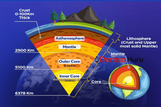
The earth’s structure is composed of two parts: internal and external. The internal structure sometimes referred to as the inner zones consists of three concentric layers: crust, mantle and the core. These layers are classified based on the density of their rock.
CROSS SECTIONAL VIEW OF THE INTERNAL STURUCTURE OF THE EARTH

CONCENTRIC ZONE OF THE EARTH
The inner zones of the earth constitute the internal structure of the earth. The inner zone / internal structure of the earth consists of three zones or layers which are: 1. Crust
- Mantle
- Core
1. CRUST
Is the outermost and thinnest zone of the earth which found between 8 – 50 km or 5 – 30 miles. It is known as Lithosphere, It is largely composed of igneous rocks. Other types of rocks also exist as a result of changes on the earth’s surface.
The rocks are crystalline, hard and brittle. Bacause of being brittle they tend to break when subjected to stress or forces especially the compressional forces. The crust also consist of two layers are sial and sima layers. SIMA and SIAL are separated by the layer called Conrad discontinuity.
a) SIAL
Is the outer layer of the crust which rich in silica and Aluminum minerals. The sail for the basis of the continent. The presence of silica and aluminum minerals collectively form SIAL layer.
b) SIMA
Is the layer which found beneath the sial. It is the inner layer of the crust which separated from sial layer by the zone called Conrad discontinuity line. The sima layer is composed by silica and magnesium. It forms the basis of ocean floor.
Note: Sial and sima layer together forms the crust.
2. MANTLE
Mesosphere or mantle which found between the crust and core. It lies beneath the crust. Mantle separated from the crust by the layer called Mohorovic discontinuity or moho, named after the seismologist Andrija Mohorovicic, who discovered it in 1909. It extends downward from 51 kilometeres to about 2900 km (1800 miles) where the temperatures may reach about 50000C. It consist of pale green minerals called Olivine (Ferromagnesium silicate) in form of ultra basic rock.It consists of lower and upper mantle. The upper mantle is rigid and crust to form a large layer called lithosphere.
The lower mantle is less rigid and forms the moltern layer within the earth’s interior called asthenosphere. Asthenosphere is the molten layer layer which responsible for the balancing movement of the earth’s material called isostatic readjustment. Asthenosphere has been investigated is found between 100 to 200 km below the upper surface.
3. CORE
The core is the innermost zone of the internal structure of the earth. It is also called barysphere. It has diameter of about 6900 km (4300 miles) density of about. The core is also classified into two parts i.e. the outer and inner core. It is separated from the mantle by the layer called Gutenberg discontinuity.
1. The Outer Core
It is liquid in nature due to high temperature of up to 37000c, and consist of nickel and iron (NIFE) . It is estimated to be 2100 km with density of about 10.5 gms/cc.
2. The Inner Core is thought to be solid in nature because of high pressure exerted from different parts toward the center – It composed mainly by iron. It has diameter of about 2600 – 2700km. (1600 – 1700 miles)
THE ROLE OF EARTH’S INTERNAL STRUCTURE IN ROCK FORMATION
ROCKS. Are natural solid materials composed of various minerals in different ratios. Or. A rock is an aggregate of minerals in a solid state.
The rock cycle- refers to the process by which a rock transforms from one type to another. It differs in colour. Texture, density, mode of formation and resistance to erosion. They also vary in chemical composition, permeability and hardness. The crust drives the rock cycle through volcanic activity, erosion and plate movements, which form Igneous, Sedmintary Rocks and Metamorphic Rocks
Types of Rocks on the Earth’s Crust
Rocks of the Earth’s crust can be classified according to their mode of formation and chemical composition. According to the mode of formation rocks can be classified as classified as igneous, sedimentary and metamorphic.
1. IGNEOUS ROCKS
The term Igneous comes from the latin word Ignis which means fire. These are rocks that formed when molten materials cools and solidifies within or outside the earth’s crust. The origin of igneous rocks is inside the earth where they are under great pressure. Igneous rocks do not occur in layers and they don’t contain fossils. Igneous rocks solidify either within the earth‘s crust and form intrusive features or outside the earth‘s surface and form extrusive features.
Magma cools and solidifies within the crust while, Lava cools and solidifies on the earth’s crust.
Igneous rocks are formed when the molten magma is forced out from the upper mantle to the earth‘s surface, where it cools and solidifies due to low temperature. Crystals form on cooling and the rocks are called crystalline rocks.
Intrusive igneous rocks
These are rocks formed when magma flows through vents or cracks, cools very slowly and solidifies before reaching the earth’s surface. The slow cooling process of magma within the Earth’s crust forms a large crystal, such rocks include granite, gabbro and Diorite. The intrusive rocks also known as plutonic rocks are dived into two types plutonic igneous rocks and hypabyssal intrusive igneous rocks.
- Plutonic: these have solidified deep in the crust and they are seen on the surface only after being exposed by prolonged erosion.
- Hypabyssal: these have been poured on the earth‘s surface where they are called lavas.
EXTRUSIVE IGNEOUS ROCKS
These are rocks formed on the Earth’s surface. They are also known as Volcanic rocks. They are formed when magma erupts and reaches the earth’s surface as lava, then cools and solidifies relatively quickly. Example of these rocks are Basalt, pumice and Rhyolite.
Characteristics of Igneous Rocks
- Igneous rocks reflect light.
- They are not found in layers.
- They do not contain fossils.
- They are crystalline rocks.
- They are formed through cooling and solidification of magma.
- They can undergo metamorphic and weathering processes.
- They contain different minerals like iron, magnesium etc.
In Tanzania igneous rocks are found in Dodoma, Iringa and in the shores of Lake Victoria (Mwanza). The main examples are granite, gabbro, basalt and diorite. Some are found in Kilimanjaro and Rungwe (Mbeya) such as basalt, pumice, diorite, gabbro, syenite and peridotite rocks.

Granite
 Basalt rocks
2. SEDIMENTARY ROCKS
Sedimentary rocks are found in strata. Sedimentary rocks are rocks formed by depositing eroded materials transported by moving water, wind, ice, oceanic currents, waves and drift.
They result from continued weathering and erosion when sediments are accumulated, compacted and cemented together. The sediments are compacted by compression to form sedimentary rocks. Sedimentary rocks are found in layers; they contain fossils and are very soft. These are weathered particles formed through deposition and lithification processes
Characteristics of Sedimentary Rocks
- They are formed when particles or sediments are accumulated, compacted and cemented together.
- They contain fossils.
- They are found in layers (strata).
- They do not reflect light.
- They are non-crystalline rocks.
- They can undergo metamorphic process.
Types of Sedimentary Rocks according to the mode of formation
1. Mechanically-Formed Sedimentary Rocks.
These are formed through weathering process. When weathering agents erode and deposit rock particles, they are accumulated, compacted and cemented together to form sedimentary rocks.
Examples of mechanically formed sedimentary rocks are clays, gravels and alluviums (all deposited by water), moraines, boulder clay and gravels (deposited by ice) and loess (deposited by wind); sandstones and shale.

Sandstone
2. Chemically-Formed Sedimentary Rocks.
These are formed through chemical precipitation process. They include carbonate (as it is in stalactite and stalagmite), sulphate, chloride, etc. The main examples are gypsum, rock salt, lignite, dolomite, flint, borax, limonite, haematite, etc.

Dolomite
3. Organically-Formed Sedimentary Rocks
These are formed through mineralization process of decaying and decomposition of dead organisms such as animals and plants. The remains of living organisms are accumulated, compacted and cemented together to form these sedimentary rocks. The main examples are chalk (limestone) and coral (formed from animals), and peat, coal and lignite (formed from plants).

Limestone

Chalk
 Coal
Coal  coral rocks
3. METAMORPHIC ROCKS
The word Metamorphic is derived from two Greek words, “META” means Change and “MORPH” which means form, general means, metamorphic means to change form. These are rocks which have changed from one type of rock to another due to the contact of heat, pressure or both. This process is referred to as metamorphism. Any rock can be changed into a metamorphic rock. Examples of metamorphic rocks are slate, marble and granite.
Three main types of Metamorphic rocks based on their mode of formation
1. Dynamic metamorphism.
This is influenced by pressure of the earth’s crust. Examples; Shale to Schist, Clay to Slate, Granite to Gneiss
2. Thermal or contact metamorphism.
This is caused by intense heat. This can take place when the rock comes into contact with hot molten material like magma or lava. Examples: Lime stone to Marble, Sand stone to Quartzite
3. Thermal dynamic metamorphism
This is the process that takes place as a result of a combination of heat and pressure. It is when the existing rocks are subjected to both pressure and heat to change their shape and appearance. Example Coal to Graphite
Characteristics of Metamorphic Rocks
- They are very hard due to prolonged action of heat and pressure.
- These rocks can change to another to another type of rocks.
- They can undergo weathering process.

Slate
ROCK CYCLE
Rock cycle is a relationship in which rocks tend to change from one type of rock to another. This is the cycle in which rocks tend to change from one type to another. For instance igneous rocks may change to metamorphic rocks or sedimentary rocks; sedimentary rocks to metamorphic or igneous rocks, etc.
Necessary Conditions for Rock Cycle to Take Place or Process of Rock Cycle
First, the molten rocks erupt from the interior of the earth and then cool and solidify to formigneous rocks.
Secondly, the igneous rocks are subjected to denudation process to form sedimentary rocks.
Third, either igneous or sedimentary rocks undergo metamorphism, due to prolonged heat and pressure, to form metamorphic rocks.
Fourth, metamorphic or igneous rocks can undergo weathering process through erosion and transportation of sediments which are further deposited in layers in the ocean or lake floors where they are cemented and consolidated to form sedimentary rocks and vice versa.
Fifth, metamorphic or sedimentary rocks can be subjected to heat and pressure where melting take place and later cooling, due to low temperature, to form igneous rocks.

Rock Circle
The Importance of Rocks
1. Rocks are very important in the formation of soils which can be used for agricultural production.
2. Rocks are used for building purposes: some rocks such as limestone, sandstone, gravels and sand are used for building houses, construction of roads, etc.
3. Some rocks are used as sources of energy or fuel such as coal and petroleum (mineral oil).
4. Limestone is widely used for cement manufacturing. In Tanzania, cement is produced at Tanga, Mbeya and Wazo Hill.
5. Salt extraction: salt usually originate from rock accruing strata, for instance, in Tunisia and Morocco there are large deposits of salt.
6. Manufacture of chemicals: some rocks contain nitrate or phosphate, while others have potash. This kind of rocks can be used for making dyes, fertilizers and medicines.
7. Mineral deposits: mineral ores occur in veins of some rocks such as igneous rocks. The minerals are formed when the magma coos down. Valuable minerals extracted from rocks include gold, lead, tin, silver, diamond, copper, zinc, aluminium, calcium and manganese.
8. Some rocks are so impressive such that they attract tourist to come and view them. In so doing, the country earns a lot of foreign exchange.
9. Some rocks are used for decoration of houses as ornaments or they are grinded to produce powder which is used for decoration.
INTERNAL FORCES OF THE EARTH
Forces are the processes that operate (work) within or on the earth’s crust. There are different forces that affects the earth.
Internal Forces: Also known as Endogenic forces, originate and operate within the earth‘s crust. Internal forces include vulcanicity and earth movements, that is, horizontal (lateral) and vertical (radial) movements. These forces may result into formation of several landform features.
External Forces: Also known as exogenic forces. These are natural forces that operate on the earth’s surface. The force s mainly act on the earth’s crust or close the surface of the earth. Often the features produced by these forces are seen on the surface of the earth. They include mountains, volcanoes, moraines and valleys, just to mention a few.
INTERNAL FORCES
These are forces that operate within (inside) the earth’s crust OR These are forces which operate beneath (under) the earth’s surface. These forces are generally referred to as TECTONIC FORCES.
The internal forces (tectonic forces) are divided into the following.
- Earth movement (Diastrophism)
- Vulcanism/ Vulcanicity/Volcanic erruptions

EARTH’S MOVEMENTS
Earth’s movement is the movement of the solid parts of the earth towards each other or away from one another or side way. These are also known as Diastrophism Types of Earth movement Earth movements are classified into two (2) main groups:
- Vertical or radial movements
- Lateral or horizontal movements or tangential.
1. Vertical or Radial Movements
These are the upward and downwards movements or forces .These forces cause the uplift (epeirogenic) and the downward movement (cymatogenic). These forces which cause the vertical earth movements operate from the interior upward toward the surface or downward from the surface to the interior.
The result of vertical movement
- The crustal rock to fault. When faults develop produce feature like plateaus, basin, Block Mountain (host) and escapements.
- Changes sea level because of the upward lift of the land or sinking of the land.
NB: This changes in the sea level is not eustatic changes but is due to vertical forces. The eustatic change is the changes of the sea level due to ice melt during ice ages
2. Lateral/Horizontal Movements
Are the organic forces (movement) because they are on the process to build mountains. Orogenesis means the process of mountain building. There are two (2) types of lateral forces: 1) Compressional forces 2) Tensional forces.
i. Compressional Forces
Are forces which move towards each other i.e move against each other. They tend to shorten the crust (the land) i.e. they squeeze the land. Compressional force causes the following.
- Folding of land hence fold mountains
- Break the land to form faulting which may produce features like block mountains, rift valley and faults.
ii. Tensional Forces
Are forces that tend to stretch the land i.e. the force move away from each other, they pull the land away. The forces cause faulting of the crust and produce features like faults, Block Mountains, and Features associated with earth movements

Folding this refers to the bending of the Earth’s crust caused by compressional forces. The folds are formed when the crust is subjected to weak and intense compressional forces. As a result, upfolds (anticlines) and downfold (syncline) emerge. The sides of the fold are called limbs.

1. Simple folds or symmetric fold
The fold has equal limbs or a types of fold in which the limbs incline at same angle.

2. Asymmetric fold
This is the fold with one limb steeper than the other.

3. Over fold (Recumbent fold)
One anticline limb of the asymmetrical fold is pushed over the other due to intensive folding movements by compressional forces on one side.

4. Overthrust fold (nappe)
Fold formed when one limb of overfold is pushed further over another limb due to compressional forces. It occurs when temperature is very great a fracture occurs in the fold (such that one limb breaks off)and the one limb is pushed over the other limb along the line of thrust plane

FAULTING
Faulting: is the process which involves the fracturing of the crust rock due to tectonic forces to form faults.
This process is associated with the movement. The rock block (i.e. rock displacement
A fault –is a fracture in the crust due to stress or strain associated with rock displacement.
Fault is cause by both tensional and compressional forces
Joint: is a crack in the rock due to stress but is not associated with rock displacement


TYPES OF FAULTS
A fault is a fracture or rupture in the crustal rock that causes dipalcement of its sides relative to each other. There are five types of faults:
1. Normal fault
A normal fault is a type of fault in which the hanging wall moves downward relative to the footwall due to tensional forces in the Earth’s crust.

2. Reverse fault
A reverse fault is a fault where the hanging wall moves upward relative to the footwall as a result of compressional forces.

3. Transform fault
A transform fault is a fault along which two blocks of the Earth’s crust slide horizontally past each other without creating or destroying crust, mainly due to shearing forces.

4. Overthrust fault
An overthrust fault is a low-angle reverse fault in which one block of rock is pushed over another for a considerable distance due to strong compressional forces.

5. Monocline fault
A monocline fault is a type of fault-related fold where rock layers are bent in a step-like form, showing a single direction of dip, usually caused by movement along a fault at depth.
Vertical movement
Vertical movement also known as Radial movements. The movements occuring either upward or downward within the earth’s crust. Vertical movement also referred to as pyrogenic movements because they are usually on a large scale.
BLOCK MOUNTAIN (HORST)
A block mountain refers to a table-like mountain formed due to the influence of faulting that leads to rising of crustal rocks. It is nearly a flat surface. A block mountain can be formed by either tensional or compressional forces. This is when the earth’s movements cause parallel faults which results into uplifting of some parts. Examples of Block Mountains are: Usambara and Uluguru, in Tanzania, Ruwenzori, in Uganda, Vosges and Black Forest, in Europe; and Mount Sinai in Asia.

PLATEAU
A plateau is a large, extensive uplifted part of the earth’s crust which is almost flat at the top. The top of the plateau is mostly a plain. Plateaus were formed during Mesozoic and Jurassic eras.
It was due to uplifting of the earth’s crust. Such landforms are East African and Brazilian plateaus. High plateaus especially in tropical latitudes are used for agriculture and settlement.
BASIN
A basin is a large, extensive depression on the earth’s surface. Most basins are formed due to vertical movement of the earth. Examples of basins include: an inland drainage e.g. Congo basin, Chad basin; and Amazon basin.

RIFT VALLEY
Rift valley is a trough or hollow which may result from both vertical and lateral movements of the earth’s crust. It is formed when two faults develop parallel to each other. It can develop either by tensional forces or compressional forces.
Formation of Rift Valley by Tensional Forces
This is formed when tensional forces move away from each other. These forces of tension produce faults and the block between two parallel faults subsides to form a rift valley.
Formation of the Rift Valley by Compressional Forces
This is formed when horizontal forces act towards each other. These forces of compression produce faults on the outside of the two parallel faults and the pieces of land on either side are lifted up above the general level of the ground to form a rift valley. Diagrammatically, formation of the Rift Valley occurs like this:

Examples of rift valleys include:
- East African rift valley – Africa
- Jordan rift valley – Asia
- Rhineland rift valley – Europe.
VULCANISM / VULCANICITY
Vulcanicity or volcanism is the range of processes by which molten materials and gases are either intruded (injected) or extruded (ejected) into the earth’s crust or into the earth’s crust respective Vulcanicity is the formation of various feature due to the intrusion or extrusion of molten materials, and gases. The molten materials are called magma when found within the earth’s crust and magma when poured on the earth’s crust.
Vulcanicity therefore includes volcanic eruptions, which lead to the formation of volcanoes and lava plateaus and geysers, and the formation of volcanic features such as batholiths, sills and dykes, etc, in the earth‘s crust.
There are two types of vulcanicity namely:
- Intrusive Vulcanicity
- Extrusive Vulcanicity
A. INTRUSIVE VOLCANIC FEATURES
This is when magma intruded within the earth’s interior. The features resulted due to the intrusive volcanic eruption is called intrusive features. The intrusive volcanic features are the features which are found within the earth’s interior.
These include the following:
1. Dyke
It is wall like structure formed when magma cools and solidifies vertically across bedding planes of the rocks.This is a wall of rock which cuts across the bedding planes. It is Examples of dykes are Mwadui dyke in Tanzania, Gabbro dyke in Lesotho, and Tyolo dyke in Malawi.

2. Sill
This is a rock sheet formed when the magma solidifies horizontally along the bedding plane. It is concordant with the rock strata. Eg: Kinkon Falls found Fouta Djallon ranges in Guinea.

Sill
3. Laccolith
This is an intrusive feature which looks like a dome. It is formed when the magma cools and solidifies in anticline bedding plane. It looks like a mushroom. E.g: Morafanobe in Madagascar.

Laccolith
4. Lopolith
This is a saucer-shaped mass of rock formed in the geosyncline. The saucer-like shape may be due to the increased weight of the deposits. E.g: The Bushveld Basin in the Transvaal in South Africa.

Lopolith
5. Phacolite
It is a lens shaped strip of igneous rock formed when the magima solidies along the anticline or syncline. Eg: Cordon wills in U.K

6. Batholith
It is the large mass of solidified rock formed when magma cools plutonically at the great dept Eg: at the heart of the mountain ranges. Eg:- Chilu Batholic in Gabon

B. EXTRUSIVE VOLCANIC FEATURES
These are the features formed when the magma cools and solidifies on the earth’s surface. The following are landforms due to extrusive vulcanicity:
1. Ash and Cinder Cone (Scorio Cone)
It is a cone shaped accumulation of rock fragments around the vent. The slopes of the cone are always concave due to the spreading tendency of lava at the base of the cone. E.g: Busoka and Bitale in South West Uganda.

Ash and Cinder Cone
2. Composite Cone (Strato Volcano)
It is a large cone with alternate layers of pyroclasts (fragments) i.e. ash and cinder on the other hand. E.g: Mount Kilimanjaro, Meru in Tanzania, and Virunga ranges in Uganda.

3. Volcanic Plug (Plug Dome Volcano)
It is a rigid cylindrical plug formed when very viscous lava is forced out by very explosive eruptions. The plug is extruded amid clouds of hot blowing ash and cinders. E.g:Hoggar Mountains in Algeria.

4. Acid Lava Cone (Cumulo Dome Volcano)
It is a dome shaped volcano with convex slopes formed when acidic lava solidifies around the vent.. E.g: Ntumbi Dome located in East of Mbeya, Tanzania.

5. Crater
It is a depression formed on the summit of the cone after the plug has been

6. Caldera
It is a large crater (large rounded depression) formed when the upper par of the volcano is either bombarded away by violent eruptions or subsides into the crust or in the volcanic cone. E.g: Ngorongoro in Tanzania, and Eboga Crater in Cameroun.

Minor Volcanic Features
1. Geyser
Geyser refers to the forceful emission of hot water and steam from the ground to a high level in the air. The ejected water contains fine materials such as volcano mud, which later form fertile soils. Geysers are found in Iceland, North Island and New Zealand.
2. Hot Spring
Hot spring refers to natural outflow of superheated water from the ground. It contains mineral substances in solution. Hot springs are found in Iceland, in Europe; and Kenya and Ethiopia, in Africa. Hot springs are also found in Manyara National Park, Songwe, in Mbeya and in Nigeria.

Geyser and Hot Spring
Classification of Volcanic According to Activity
1. Active Volcano: is the volcano which erupts frequently. Eg:- Oldonyo Lengai in Tanzania and Mount Cameroon.
2. Dormant Volcano is the one which has stopped erupting but not extinct and it is expected to erupt. The dormant volcano is also known as sleep volcano.
3. Extinct Volcano. Is the volcano which has stopped erupting for a very long time in history and is not expected to erupt. It is also known as dead volcano.
THE ECONOMIC IMPORTANCE OF VOLCANIC ACTIVITIES
The following include the economic importance of volcanic eruptions to man.
- Lava on weathering lead to the formation of very fertile soil which support agriculture.
- Volcanicity eruption lead to the formation of mineral deposits like copper deposits of butte in USA, diamond of Kimberley in South Africa.
- Volcanic eruption provides geothermal power for electric generation IV. Some hot springs utilized for heating homes in glaciated region V. Volcanic features attract tourists.
VI. Volcanic cones are the source of rivers.
NEGATIVE EFFECTS OF VOLCANIC ERUPTION
- May kill people and destroy properties.
- It destroy Agricultural land since the solidified lava hardens making it difficult for farmers to cultivate the land.
- Volcanic eruptions may release poisonous gases such as Sulphur dioxide and carbon dioxide adversely impacting human beings and the atmosphere.
EARTHQUAKE
Earthquakes refer to the sudden shaking or vibrations of the earth’s crust due to sudden and rapid displacement of tectonic plates along the line of weakness (faults). It occurs mainly in volcanic eruption zones.
The point from which the earthquake originates is known as focus and the intensity of earthquakes can be measured by using an instrument called seismograph. The point on the surface vertically above the focus is called epicenter
Measurement of Earthquakes
The intensity and magnitude measure the strength of the earthquake. Earthquake can be measured and detected by using instruments called seismograph or seismometer.
Intensity is a measure of how hard the earthquake shakes the ground. It is determined through the effects produced by the earthquake. Intensity varies from one place to another. While the intensity of a specific earthquake varies, its magnitude does not vary. So it is important not to confuse magnitude with intensity.
The scale that measures the intensity is called Mercalli scale. It ranges from undetectable, moderate, strong to major catastrophe. Magnitude refers to the total amount of energy released and it is given on the Ritcher scale. This scale ranges from 0 to 8.9.
Causes of Earthquakes
- Plate tectonic movement, where one plate slides over another plate.
- Volcanism, can cause occurrence of the earthquake. This is because the magma moves under the influence of intense pressure from within the earth’s interior.
- Mass wasting, like land slide and rock fall can cause occurrence of earthquake, but this is for local scale.
- Falling objects from the atmosphere, such as meteorites may lead to the shaking earth’s crust.
- Man’s influence through his activities such as mining using explosives like dynamites and transport vessels like trains and heavy trucks.
Effects of Earthquakes
They can cause loss of life and property
An earthquake is a natural disaster. Whenever it occurs, it causes a lot of disturbances including loss of life and properties. For example, the earthquake that hit Toro in Uganda in 1966 killed 157 people, injured about 1300 people and destroyed about 6000 houses. The earthquake which occurred in California–Mexico border in 1975 caused damage running into millions of dollars and injured 100 people on both sides of the border where most of them suffered cuts from flying glass and debris.
They can displace parts of the earth’s crust vertically or laterally.
They can raise or lower parts of the sea floor.
The Agadir earthquake in Morocco in 1960 raised the sea floor of the coast. In some areas the depth of the sea decreased from 400 m to 15 m after the earthquake.
They can raise or lower coastal rocks.
In the Alaskan earthquake of 1899, some coastal rocks were raised by 16 m.
They can cause landslide and open up deep cracks in the surface rocks.
The El Asnam earthquake in Algeria, in 1954, destroyed an area of radius 40 km and opened up deep cracks up to 3 m deep.
Lead to the outbreak of fire like what happened in forest of Amazon.
Precautionary Measures to Avoid high Damage from Earthquakes
- Refraining from building high-rising structures on the land vulnerable to earthquake as well as strengthening buildings by using reinforced concrete, steel frames, deep foundations and light roofs.
- Geologists should detect epicenters and tell the people to evacuate the places likely to be affected by earthquakes.
- To avoid constructing very large water bodies like Kariba dam which can cause the earthquakes due to the weight of water and other materials.
- Discouraging the use of explosives like dynamites in breaking the rocks during mining and construction operations.