PHOTOGRAPH READING AND INTERPRETATION
Definitions of Photograph
Photograph is picture produced by using a camera or satellite or radar, and then made visible and permanent by chemical treatment, or stored digitally. OR
Photograph is a picture taken by means of chemical lights prepared on a special paper. OR
Photograph is an image of an object which is recorded by a camera and then printed on paper.
Photograph interpretation is a process of reading, measuring and interpreting photographs for obtaining reliable information about natural or human features and their environment.
In other words, photograph interpretation can be defined as analysis and examination of photographs so as to be able to identify natural or artificial features.
Types of Photographs
- Ground (Horizontal) Photographs
- Oblique Photographs
- Vertical Photographs
1. GROUND LEVEL PHOTOGRAPHS
Are pictures taken horizontally whereby the camera and the object are at the same level. It is a picture taken when the camera axis is horizontal to the object. It is a camera taken at 1800 . These are the photographs taken on the level grounds when the optical camera axis is horizontal to the object.

TYPES OF GROUND/ HORIZONTAL PHOTOGRAPH
Panorama horizontal photography
are general view photographs that show many items on an extensive landscape. They show one side of the features, with very wider horizon in the background. Panorama photograph can be obtained by takin multiple photographs and combining or stitching them together or taking one image using a camera with a wider format lens.
Closed-up horizontal photograph
This is a particular view photograph focusing on ne specific object that needs to be interpreted.
Characteristics of Ground Level Photographs
- The camera is at the same level as the object being photographed at 180o.
- They show only the (front) side view of an object
- The camera is close to the Object.
- Its scale decrease from the foreground to the background
- It covers a small area.
- It does not show the top view cleary.
- The fore ground and the horizon is seen but the back /dead ground is not seen
2. OBLIQUE PHOTOGRAPHS
These are the photographs taken from hills looking down with camera towards the ground. Sometimes they are taken from low flying planes, towers or from tall building at 450 to 800 Or, are the photographs taken when a camera is slanting at an angle less than 90°. They are taken when the photographer is standing on an elevated ground and hold the camera on an angle towards the lower ground. They normally cover the horizon.
Types of Oblique Photographs
- Low oblique Photographs
- High Oblique Photographs
A) LOW OBLIQUE PHOTOGRAPHS
These are the photographs taken with camera tilted not to include the horizon the photograph. Or, these are taken when the photographer is standing in elevated ground, such as top of a hill, building or cliff, and holds the camera at an angle pointing towards the lower ground.
The photograph can also be taken when the photographer is standing at the bottom of an elevated ground, with the camera pointing towards the higher ground.

Characteristics of Low Oblique Photographs
- It covers a small area
- It does not show the horizon
- It shows the top and front views of the objects
- They are taken from an elevated area at 45°(for example: from the top of the mountain)
- The features in the fore and middle ground are shown clear
B) HIGH OBLIQUE PHOTOGRAPH
These are photographs taken with the camera tilted to include the horizon. Or, these photographs are taken from the sky with the camera tilted at an angle towards the ground. The photographer may take the photograph from a helicopter or low flying aeroplane. These photographs cover quite a large area of land.

Characteristics of High Oblique
- They show large area
- They are taken at 60
- They show the horizon
- They show both the front and top view
- They are important in map making
NB: Oblique Photographs can be Low Oblique (if the horizon is not visible) or High
Oblique (if the horizon is visible)

Low Oblique versus High Oblique Photographs
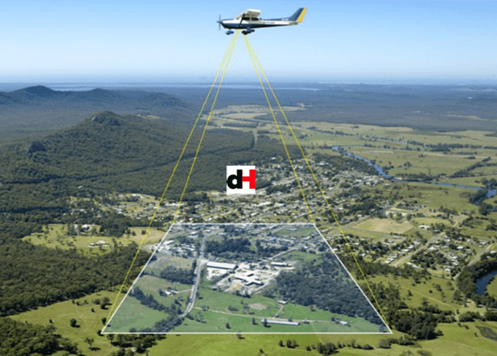
3. VERTICAL OR AERIAL PHOTOGRAPHS
These are photographs taken with camera whose axis tilted vertically to the ground at right angle (90°). These are photographs taken from the aircraft with the camera directly above the object pointing vertically to the ground. Only the top view is seen.
Instruments used to capture pictures are called air crafts or the satellites

Characteristics of Vertical Aerial Photographs
- They cover a lot of information of a given photographic area
- Only the top view of the feature is seen
- They are taken vertically at 900 with camera positioned above the scenery.
- They are taken from the air
- They are taken when the camera is placed vertically towards the object
- They can be used in map making
- They contain a lot of detailed information of a given photographic region since they print everything
Uses of Vertical Aerial Photographs
- They are used for plotting contour lines
- They are used for map making
- They are used for military purposes
- They can produce variety of scales like small scale and large scale
- They are used for pilot studies before conducting field trip
- They can be used for investigation or researches
- They can be also used for rapid survey of unknown area like thick forests and high mountains
Differences between Oblique/Ground Photograph and Vertical Photograph
- It is difficult to recognize the image of the Vertical photographs while the image or picture of Oblique photographs is easily recognized
- It is easier to determine the scale in Vertical photographs than in Oblique photographs
- Vertical photographs show the top view while Oblique photographs show the top and front view.
- It is difficult to identify objects in Vertical photographs than in Oblique photographs.
- In Vertical photographs, all important features are seen while in Oblique photographs some important features are not seen.
- Oblique photographs are less expensive than Vertical photographs
Comparisons between Photographs and Maps
- Both photographs and maps are important in learning geography
- They both have scales
- Both are used in military for techniques
- Both show the physical and relief features on the earth
- Both are used by planners when planning for something or a project 6. They both represent the three dimensional World on the flat surface
Differences between Maps and Photographs
| MAPS | PHOTOGRAPHS |
| They have keys | They have not keys |
| They are selective it show only what was intended to be presented | They are not selective as they print everything |
| Maps have a north direction | Photograph do not show direction |
| They have titles | They do not have written titles |
| They are very expensive | They are less expensive and fast |
| They take much time in making a map | They take less in producing a photo |
| The scale is constant or uniform | The scale is not constant or uniform |
| They need skills to interpret them | They are very easy to interpret |
| Maps are prepared from photograph | Photographs are not produced from maps |
SATELLITE IMAGES
Are digital images or pictures of the Earth’s surface taken from space by special cameras on satellites. These cameras and sensors capture images in difficult ways some detect sunlight just like normal cameras while others detect heat or radio waves. Since the satellites orbits are at a higher altitude above the Earth’s surface they take images
Satellite images can be grouped based on how they were captured and the type of information they proved:
1. An optical image is an image formed when light rays from an object are reflected or refracted by a mirror or a lens.
2. An infrared image is an image formed using infrared radiation that shows the heat or temperature differences of objects.
3. A radar image is an image produced when radio waves sent from a radar system hit objects or the Earth’s surface and are reflected back, allowing the size, shape, position, and movement of features to be detected, even at night or through clouds.
4. Multispectral image: An image captured using a few broad wavelength bands of the electromagnetic spectrum, allowing different surface features to be identified and compared.
5. Hyperspectral image: An image captured using many narrow and continuous wavelength bands, providing very detailed information about the composition and characteristics of surface features.
USES OF SATELLITES IMAGES
- Help to see and understand different parts of the world from above, including remote and inaccessible regions.
- Weather forecasting – to observe clouds, storms, rainfall, and cyclones.
- Climate studies – to monitor climate change, temperature trends, and ice melting.
- Map making (cartography) – to produce accurate maps and update existing ones.
- Agriculture – to monitor crop health, estimate yields, and plan irrigation.
- Environmental management – to detect deforestation, desertification, and pollution.
- Disaster management – to assess floods, droughts, earthquakes, and volcanic eruptions.
- Urban planning – to monitor town growth, land use, and infrastructure development.
- Natural resource exploration – to locate minerals, oil, gas, and water resources.
- Military and security – for surveillance, border monitoring, and strategic planning.
PHOTOGRAPH READING AND INTERPRETATION
Is the process of reading, measuring, translating and explaining the meaning of objects identified on that photograph. It is done so as to obtain reliable information about the natural or cultural features on their environments. It involves the following;
- Determining the title Estimating time and the season
- Estimating direction Identifying and interpreting physical features Identifying and
- Interpreting human activities
- Estimating the size of features Suggesting possible location of the scenery in the place
Estimating Time
It is possible to estimate the time of day when the photo was taken if we know where the photograph was taken If the photo was taken during the morning its evidence is through the shadow
1. During the Morning: The shadow of the object lies in the western side because the sun rises from the east
2. During the Evening: The shadow lies in the eastern side because the sun sets on the west
3. During the Afternoon: The shadow lies around the object because the sun is over head of the object
SEVERAL ELEMENTS USED TO IDENTIFY AND DESCRIBE FEATURES IN THE PHOTOGRAPH
Elements are the visual characteristics of features in a photograph that help an observer to identify, distinguish, and describe objects on the Earth’s surface. Below is a description of each element used in photograph interpretation: 1. Tone
This refers to the degree of brightness or darkness of features in a photograph. Different objects reflect light differently, so they appear light, dark, or medium in tone, helping to distinguish one feature from another.
a. Shape
Shape refers to the outline or form of a feature as seen in the photograph. Regular shapes often indicate human-made features (such as buildings and roads), while irregular shapes usually indicate natural features (such as rivers and forests).
b. Texture
Texture describes the surface appearance of a feature, whether it looks smooth, rough, coarse, or fine. It is determined by the size and arrangement of objects within an area, for example grassland appears smooth while forest appears rough.
c. Pattern
Pattern refers to the spatial arrangement or repetition of features on the ground. It may be linear, circular, rectangular, scattered, or clustered, and it helps to identify both natural and human activities.
d. Shadow
Shadow is the dark area formed when an object blocks light. Shadows help to
show the height, shape, and position of tall features such as trees, buildings, and hills.
e. Association
Association refers to the relationship between a feature and other nearby features. Certain features commonly occur together, for example harbours are associated with water bodies and roads, while farms are associated with cultivated land and settlements.
f. Location (Site and Situation)
Location refers to the position of a feature in relation to other features or to its geographical setting. Some features are found in specific locations, such as ports along the coast or dams across rivers.
g. Prior knowledge of the photographed area
This is the existing information or experience an observer has about the area being studied, such as climate, relief, vegetation, or human activities. Prior knowledge helps in making accurate interpretation and reducing errors.
IDENTIFYING AND INTERPRETING RELIEF AND PHYSICAL FEATURES FROM A PHOTOGRAPH
Photographs are important tools for identifying and interpreting relief and other physical features on the Earth’s surface. Relief and many physical features such as vegetation, water bodies, and rocks can be identified and interpreted by carefully observing the photograph.
1. Relief features
Relief refers to the variation in height and shape of the land surface.
• Flat landscapes
These are identified by uniform tone, absence of shadows, smooth texture, and straight or gently curving features. Examples include plains and plateaus, which often support agriculture and settlements.
• Mountainous areas
These are identified by steep slopes, strong shadows, irregular shapes, and rough texture. Mountains may appear with ridges, peaks, and deep valleys, indicating high relief and rugged terrain.
2. Water bodies
Water bodies such as rivers, lakes, seas, and ponds can be identified by their smooth texture and usually dark tone in photographs. Rivers appear as long, winding features, lakes appear as wide enclosed shapes, and seas or oceans occupy extensive areas along the coast.
3. Rocks
Rock outcrops are identified by their rough texture, irregular shape, and light or varied tone. Areas with exposed rocks often have little or no vegetation and may appear bare or broken on the photograph.
4. Vegetation
Vegetation is identified by its tone, texture, and pattern. Forests appear dark and rough in texture, grasslands appear lighter and smoother, while cultivated vegetation shows regular patterns such as rows or rectangular fields.
IDENTIFYING AND INTERPRETING HUMAN ACTIVITIES
Human activities on a photograph are depicted by various forms of land use. The uses of land may in form of agriculture (crop cultivation and animal husbandry), forestry, settlement, wildlife conservation, mining and construction of infrastructures, among other uses.
To interpret land use or human activities in a photographed area, the following clues can help:
- Natural vegetation of the area for example, grassland or shrubs vegetation may suggest GRAZING ACTIVITIES.
- Presence of estates or farms suggests CROP FARMING and sometimes INDUSTRIAL WORKS.
- Presence of Domestic animals suggests GRAZING while wild animals may suggest TOURISM ACTIVITIES.
- Presence of river or coastal plains indicates FISHING ACTIVITIES
- Communication networks, Markets and Shops suggest TRADING ACTIVITIES.
- TOURISM ACTIVITIES also may also be noted by attractive features such as Beaches, caves, crater, thick forest and Zoos.
- Mines indicate MINING ACTIVITIES.
- Factories indicate INDUSTRIAL WORKS • Forest indicates LUMBERING ACTIVITIES.
SETTLEMENT
A settlement comprises of a group of buildings in an area where people live and carry out social and economic activities. There are two types of settlements; rural and urban settlement.
Rural Settlements
This can be indicated by the following features:
1. Many semi-permanent and a few permanent buildings such as grass-thatched houses or ironroofed houses with mud or brick walls 2. Evidence of farming, fishing activities etc.
3. Unplanned or unevenly distributed of settlement which associated with plantations etc.
Urban Settlements
This can be identified by the following features:
- Permanent buildings, which dominate the area
- Regular street patterns
- Many large buildings and warehouses indicating an industrial area
- High numbers of people or population
- Availability of Many motor vehicles on the road, which may lead to traffic jams
SETTLEMENT PATTERNS
It is a layout of dwellings in a particular place. The signs showing settlements on topographical maps are observed to have varied arrangement. The most common pattern include the following:
1. Dispersed Settlement Pattern
It is alternatively called scattered settlement pattern. The houses are widely spaced one to another

2. Nucleated Settlement Pattern
Houses and other related form are compacted to another.

3. Linear Settlement Pattern
Houses are concentrated along an elongated objected of economic significance like a road, river, railway lines and others

Factors Encouraging Settlements
- A reliable source of water supply e.g. presence of permanent rivers, lakes.
- Gentle slope i.e. people prefer to establish settlement in less hazardous areas
- Good soil for agriculture
- Pleasant climate condition 5. Transport and communication.
PARTS OF PHOTOGRAPH
A photograph has main three parts or divisions. These parts includes:
i) Foreground
ii) Middle ground
iii) Back ground

KEY
LHS = Left Hand Side
RHS = Right Hand Side
Importance of Photographs reading and interpretation
The Value or Importance of Photographs reading and interpretation in our Daily Life:
- Photographs store information for future generation
- They act as main house of information of a place
- Photographs are used to prepare the topographical maps
- They provide quick and instant information than maps
- They replace verbal description and save time
- They show real feature of the earth and provide a good visual impression for observation and interpretation
- Photographs are also used in geographical research