The Movement of The Earth in the Solar System
Download Geography Notes For Topic 3: The Movement of The Earth in the Solar System – Geography Notes Form One New Syllabus, Form one Geography Notes New Syllabus.
Our planet Earth is not static. It is constantly in motion, which makes it dynamic in nature. This motion affects the Earth as a planet and all other life forms found on it.
Therefore, in this lesson, you will learn about the movements of the Earth in the solar system and their effects. Such movements include rotation and revolution of the Earth. Also, you will study about the imaginary lines on the earth’s surface.
Such lines include parallels and meridians. The competencies developed will enable you to understand the natural world and inform many aspects of our daily life.
It will also help you to monitor and predict different events of the Earth as a celestial body, as well as to plan different activities according to time and seasons of the year.
Rotation of the Earth
Activity 1
Read from library and other reliable online sources and search for simulation videos on the meaning of the earth’s rotation, then make short notes.
How the Earth rotates
When travelling in a fast-moving vehicle, while looking outside, the trees and other objects outside the vehicle appear to move in the opposite direction. This observation is similar to the movement of the Earth in relation to the sun. Based on this scenario, the one moving is the person in the moving car not the trees or objects outside the vehicle.
This is just like the rotation of the Earth; it is the Earth that rotates, not the Sun. The term rotation means spinning of a body on its axis. An axis of the Earth is an imaginary line joining the North and South Poles through the centre.
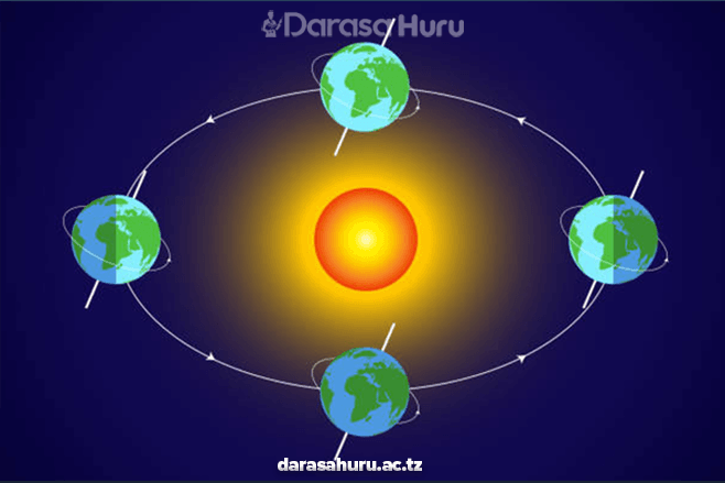
The earth’s axis is tilted making an angle of 23½° from the perpendicular. The earth rotates on its axis in an anticlockwise direction, from West to East through 360° in 24 hours (Figure 3.1). This means that, the earth takes 1 hour to rotate through 15°, which is equal to 4 minutes for every 1°.

Exercise 1
1. Explain the concept of the earth’s rotation.
2. Explain the importance of the earth’s rotation in your daily life.
3. Differentiate between the earth’s axis and the earth’s line of perpendicular.
Evidence of the earth’s rotation
Activity 2
Search for evidence of the earth’s rotation from library and other reliable online sources.
The earth’s rotation changes from no movement at the poles to very fast movement at the equator. We do not feel the motion because we move with it. At the equator every point of the earth’s surface moves eastwards at about 1600 kilometres per hour. We do not feel this motion because we move with the earth’s movement at a constant speed. At latitude 40°, the speed is about 1280 kilometres per hour. In the meantime, at the poles, the speed is zero (0) kilometre per hour. There are several pieces of evidence which show that the Earth is rotating. These include:
Sunrise and sunset
The Sun is located at the centre of solar system; it does not move. Instead, as the earth rotates from the West to the East, the Sun appears to rise from the East and set to the West. It is this movement of the Earth which explains sunrise and sunset.

Day and night
The most apparent evidence of the earth’s rotation is the cycle of day and night. The Earth is a sphere. As it spins on its axis, different parts of the planet face the Sun at different times, resulting into daylight in one area and darkness in the other.

Shape of the Earth
The Earth is not a perfect sphere. It is slightly flattened at the poles due to the absence of centrifugal force and strong gravitational pull. Meanwhile it bulges at the equator because of strong centrifugal force and weaker gravitational pull. All these factors are caused by unequal rotational speed at the poles and at the equator, respectively.

Star Trails
When you look at the night sky, stars appear to make a circular movement around the North or South Poles, from East to West. In fact, the stars do not move, this happens because the Earth is rotating on its axis from the West to East.

Time Zones
The division of the Earth into different time zones (24 hours) is based on the earth’s rotation. As the Earth spins on its axis, different regions experience daylight and darkness at different times.

Coriolis Effect
The Coriolis Effect causes moving objects, like winds and ocean currents to curve or be deflected due to the Earth’s rotation. This effect influences the direction of wind patterns and ocean currents. The winds and ocean currents in the Northern Hemisphere are deflected to the right, while those in the Southern Hemisphere they are deflected to the left.

Exercise 2
1. Why do we experience sunrise and sunset?
2. What is the impact of the Earth’s axis tilting to an angle of 23½°?
3. The sun does not move instead the Earth moves, explain.
4. Explain the consequences of the earth’s rotation to stop suddenly. How would this influence different aspects of life on Earth?
5. Why the speed of the earth’s rotation is zero (0) kilometres per hour at the poles?
The Effects of Rotation
Activity 3
Using a flashlight and a globe, demonstrate how the earth’s rotation causes day and night. Turn on the flashlight on the globe to represent the Sun’s light, while you rotate the globe to simulate its rotation. Then, present what you have observed.
Rotation of the earth has the following effects:
(i) Day and night
The change between day and night is caused by the rotation of the Earth on its axis. The side that faces the sun experiences the light from the sun (day) whereas the side that is not facing the sun at that time is in darkness (night)
Therefore, as the Earth rotates its two parts alternate between light and darkness, respectively. As such, different places on the earth’s surface experience sunrise, noon and sunset at different times in a day.

(ii) Differences in time
Rotation of the Earth causes differences in time in places located at different longitudes. Places on the same longitude have the same time. As the Earth rotates on its axis, different places of the world experience daylight and darkness at different times.
The difference in time is determined by longitudinal differences between two or more places. The Earth is 360°, it is divided into 24 time zones, each with approximately 15 degrees of longitude width, such that, each time zone represents a one-hour difference in time.
For example, if you have two places located in different time zones, one at a longitude 60° West and the other at a longitude 120° East, they will have a time difference of 12 hours.

iii) Gain or loss of a day
This effect is primarily related to crossing the International Date Line. One will lose a day when crossing the International Date Line (IDL) from the East to the West, and will gain a day when crossing the IDL from the West to the East.
International Date Line is an imaginary line that runs from the North Pole to the South Pole. It follows Meridian 180° except where it crosses land surfaces to avoid confusion. If the Earth would not be rotating, there would be neither gaining nor losing of a day while crossing the IDL.

(iv) Deflection of winds and ocean currents
The earth’s rotation causes deflection of planetary winds and ocean currents. This means that they do not blow and flow straight. The planetary winds and ocean currents are deflected to the right in the northern hemisphere and to the left in the southern hemisphere.
This is based on Ferrel’s Law, which states that ‘‘freely moving bodies are deflected to their right in the northern hemisphere and to their left in the southern hemisphere from their point of origin’’.


(v) Tides
Ocean tide is the rising and falling of water level in oceans as shown in Figure 3.4. This is caused by gravitational attraction exerted largely by the moon and partly by the Sun upon the rotating earth.
The main reason why the gravitational attraction of the moon is greater compared to that of the Sun is that the moon is closer to the Earth compared to the long distance from the Sun.
When the Earth, moon, and the sun are in a straight line, ocean water level rises and when the earth, moon, and the sun are not in a straight line, the ocean water level falls. Tides are experienced at different times of the day and at night and in different places on the earth’s surface, because the earth is rotating.

Exercise 3
1. Explain the factors that affect the deflection of winds and ocean currents.
2. What is the importance of knowledge of deflection of winds and ocean currents in your daily life?
3. Do tides happen in lakes and rivers, or just in the ocean? Why?
4. What is the importance of the low and high tides to your life?
Revolution of the Earth
Activity 4
(a) Search for videos, simulation, or animations from reliable online sources on how the Earth revolves around the Sun and how the Moon revolves around the Earth;
(b) Observe what happens during the movements, and record your observation; and
(c) Draw an illustration of what you have observed.
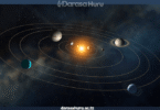
The Earth revolves around the Sun following its orbit. It revolves around the sun in an elliptical path, completing one full revolution in approximately 365¼ days or one year. However, a normal year has 365 days. The fraction days are not counted every year but are added once in 4 years to make a leap year of 366 days. The leap year occurs once in every four years, when the month of February has 29 days instead of 28. The speed of the earth’s revolution is about 29.6 kilometres per second which is estimated from the earth’s travel about 940 million Kilometres.
Effects of the earth’s revolution
The revolution of the Earth around the sun and tilting on its axis has the following effects:
(i) Seasons of the year
A season is the main period of the year with a particular type of weather. Seasons are caused by the tilt of the earth’s axis and the earth’s revolution around the sun. With respect to the orbital plane or the horizontal plane, the earth’s axis is tilted at an angle of 66½°. However, with respect to the vertical plane, the Earth has an axial tilt of 23½°.
In its revolution around the sun, one of the hemispheres is inclined towards the sun at one period of the year and away from sun at another period of the year. For example, in the months of December, January, and February, the Southern Hemisphere tilts towards the sun.
Thus, it is summer time. The same months in the Northern Hemisphere experience winter season because the Northern Hemisphere tilts away from the sun. Spring and autumn are short seasonal transitions between summer and winter, respectively. Spring is a short season towards summer while autumn is a short season towards winter.
Generally, there are four seasons in a year which are differentiated by temperature and rainfall characteristics. These seasons are summer, autumn, winter and spring. The four seasons are more pronounced in areas found between latitudes 23½° and 66½° North and South of the equator. Around 0° to 5° North and South of the equator never experience seasons because throughout the year the sun is almost overhead.
Therefore, these areas experience high temperature and rainfall. However, this part experiences seasonal variations due to differences in relief. The areas between 5o and 23 ½° North and South of the Equator are characterised by hot-wet and cold- dry seasons. The North Pole (NP) and the South Pole (SP) are normally very cold throughout the year and it is difficult to distinguish the seasons of the year in these regions.
In the Northern Hemisphere, summer months are June, July and August. Autumn months are September, October, and November. Winter season occurs in December, January, and February whereas spring months are March, April and May. In the Southern Hemisphere, the summer months are December, January, and February.
Autumn occurs in March, April, and May. Winter season in the Southern Hemisphere occurs in June, July, and August, whereas, spring months are September, October, and November (Figure 3.5). However, due to the influence of relief and oceans, these seasons do not always occur in the basis of explained sequence.

(ii) Changes of overhead sun
The position on Earth where the Sun is directly overhead changes throughout the year due to the tilt of the earth’s axis and its elliptical orbit around the Sun. The overhead sun appears to move northwards and southwards between latitudes 23½° N and 23½° S, that is, between the tropics of Cancer and Capricorn.
For example, during the summer solstice in the Northern Hemisphere, the Sun is directly overhead at the Tropic of Cancer, while during the winter solstice, it is directly overhead at the Tropic of Capricorn.
The places south of the Tropic of Capricorn and north of the Tropic of Cancer never experience overhead sun at any time of the year. This change of overhead sun creates the changing seasons and variations in daylight hours at different latitudes

Solstice and equinox
The tilting nature of the earth’s axis causes parts of its surface to receive different amount of sunlight at different times of the year. This situation leads to solstice and equinox. Solstice comes from the Latin word solstitium, which contains two words: sol the term that means Sun and sistere that means stand still. The solstice, therefore, literally means “sun-stand still”.
Solstice is a phenomenon that occurs when the earth’s poles are mostly inclined towards or away from the sun, causing the earth’s pole which is inclined towards the Sun to receive maximum sunlight. This makes the most inclined pole towards the sun to experience the longest day in the year. During this time, the Sun is vertically overhead in respective tropic on specific dates.
The southern hemisphere gets the maximum intensity of the sun’s rays on December 22nd which is the Summer Solstice in the tropic of Capricorn. At the same time, it is the Winter Solstice at the tropic of Cancer. The northern hemisphere solstice occurs on June 21st commonly known as the Summer Solstice at the tropic of Cancer. At the same time, it is winter solstice at the tropic of Capricorn.
The equinox simply refers to equal lengths of day and night. Due to the tilting of the earth’s axis, there are only two times of the year when the sun is directly overhead at noon at the equator. This results into equal distribution of sun rays between the Southern and Northern Hemispheres. The equinoxes occur on March 21st and September 23rd every year.
The March equinox is referred to as vernal equinox in the Northern Hemisphere and autumnal equinox in the Southern Hemisphere. In addition, the September equinox is known as autumnal equinox in the Northern Hemisphere and vernal equinox in the Southern Hemisphere.
Activity 5
(a) Design a globe by using locally available materials to represent the Earth. Use flashlight to represent the Sun, then place the globe at an angle to represent the Earth’s tilt;
(b) Turn on the flashlight and shine it directly at the centre of the globe, simulating the Sun’s rays;
(c) Observe the way light hits the globe and write notes on what you have observed in relation to the equinox.
(iii) Varying lengths of day and night at different times of the year.
The lengths of day and night are not the same across the world because the earth’s axis is inclined to its plane at an angle of 66½°. Had the earth’s axis been vertical to its orbital plane, all the parts of the earth would have the same duration of days and nights throughout the year.
Places along the equator experience nearly equal day and night throughout the year, but northwards or southwards towards the poles, the lengths of day and night vary with latitude.
For instance, when the overhead sun is in the Northern Hemisphere, the days are longer than the nights in that hemisphere. At the North Pole (90°N), daylight is experienced for six months without sunset. While at the South Pole (90°S), darkness is experienced for six months In contrast, when the overhead sun is in the Southern Hemisphere, the days are longer than the nights in the Southern Hemisphere. Thus, at the South Pole (90°S), daylight is experienced for six months without sunset.
Exercise 4
1. Discuss the effects of the earth’s revolution in your area.
2. Explain the common economic activities carried out in your area in different seasons of the year.
Activity 6
1. Think of your community at home town or village, and relate the seasons of the year with their daily activities. Use the following questions for guidance:
(a) What activities do they conduct in each season?
(b) Why do you think they do such activities in that particular season?
2. Write short essay on the activities done in relation to the seasons of the year.
(iv) Aphelion and Perihelion
The Earth revolves around the sun in an elliptical orbit. Due to the elliptical shape of the earth’s orbit, the Sun is closer to the Earth at one point of the year than at the other.
The furthest position from the sun in the orbit of the earth is called aphelion. Normally, the Earth is at aphelion each year on 4th July when it is 152 million kilometres away from the Sun. Perihelion occurs when the Earth is nearest to the Sun about 147 million kilometres away from the Sun.
The Earth is at perihelion each year on the 3rd of January. Aphelion and perihelion affect the amount of solar radiation received by the Earth, though their influence on the seasons is much smaller than the axial tilt. The slight variation in solar radiation due to Earth’s changing distance from the Sun during its orbit is not sufficient to cause significant climate change or shifts in seasons.

(v) Eclipses
An eclipse is a total or partial obstruction of light from the sun by either the earth or the moon. This occurs when the earth or the moon intercepts light from the sun. There are two types of eclipses: the lunar eclipse and the solar eclipse.
(a) Lunar eclipse
The lunar eclipse is also known as the eclipse of the Moon. It occurs when the Earth passes between the moon and the Sun, thus casting its shadow on the moon.

Activity 7
Search for information from the library and other reliable online sources about the phases of the moon.
Phases of the moon
The relationship between the earth’s revolution around the Sun and the phases of the Moon is what gives rise to the lunar cycle and the changing appearance of the Moon as observed from the Earth.
Moon develops different shapes or appearances as seen from Earth. It takes 29½ days to complete one cycle to revolve around the Earth. The phases are a result of the changing positions of the Moon, Earth, and Sun relative to each other during revolution. As the Moon orbits the Earth, different parts of its surface are illuminated by the Sun.
The portion of the Moon facing the Sun is lit, while the portion facing away from the Sun is in darkness. The angle at which we see the illuminated portion of the Moon changes depending on Earth’s position in its orbit.
As the Earth orbits the Sun, the Sun’s light falls on different parts of the Moon’s surface, causing the Moon’s appearance to change over time. As the Moon orbits the Earth, a sequence of phases is observed namely new moon, waning crescent, first quarter (waxing half), waxing gibbous, full moon, waning gibbous, last quarter (waning half), waning crescent.
As the moon revolves around the Earth, its illuminated part lights the earth during the night. Also, the gravitational force of the moon on the Earth causes tides in the Earth surface waters.
(b) Solar eclipse
The solar eclipse is also known as the eclipse of the sun. It occurs when the moon passes between the Earth and the Sun. The moon casts its shadow over the earth .
Eclipse of the sun is partial when only part of the earth is obscured by the shadow of the moon. The portion of the shadow that results when the light from the Sun is partially blocked is called Penumbra. Moreover, when the light from the sun is completely blocked it forms the shadow called Umbra.
Tanzania has witnessed solar eclipse in different times. For example, some parts of Tanzania witnessed a total eclipse of the sun on 23rd October 1976. In addition, partial eclipses occurred on 19th April 1977 and 14th October 2000. Meanwhile on 1st September, 2016, a total solar eclipse was witnessed in Rujewa, Mbarali District in Mbeya Region.

Significance of eclipses
Solar and Lunar eclipses are important in many ways, including their scientific, cultural, and historical significance. The following are significances of eclipse:
Facilitation of scientific exploration
Eclipses provide unique opportunities for scientists to study celestial bodies and phenomena that are not normally visible. During a solar eclipse, the moon blocks the sun’s bright disk, revealing the sun’s outer atmosphere (corona) and allowing researchers to gather valuable data about its composition and behavior. Lunar eclipses also offer insights into the Earth’s atmosphere and its effects on sunlight passing through it.
Astronomical discoveries
Historically, eclipses have facilitated significant discoveries in astronomy. For example, observations of the bending of starlight during a solar eclipse confirmed Einstein’s theory of general relativity. Eclipses have also enabled scientists refine their understanding of planetary orbits, lunar features, and other celestial phenomena.
Cultural and mythological significance
Eclipses have often been interpreted through cultural and mythological lenses. They feature prominently in various cultures’ creation stories, folklore, and religious beliefs. Eclipses can evoke a sense of wonder and mystery, leading to cultural celebrations, rituals, and narratives that have been passed down through generations.
Technological advancement
The study of eclipses has driven advancements in various observational tools and techniques. Telescopes, cameras, and other instruments have been developed and refined to capture and analyse eclipses, leading to innovations that have applications beyond astronomy.
Educational outreach
Eclipses capture public’s attention and offer excellent opportunities for science communication and educational outreach. They inspire interest in astronomy, space science, and the natural world, fostering a greater appreciation for scientific inquiry.
Environmental effects
Eclipses can have observable effects on the environment. For example, during a solar eclipse, the sudden decrease in sunlight can lead to changes in temperature and animal behavior. These effects provide researchers with opportunities to study how living organisms respond to temporary changes in light and temperature.
Global interrelationship
Eclipses are events that people all around the world may witness and share, fostering a sense of global connection and unity. The ability to experience the same celestial phenomenon from different locations on Earth has the potential to bring people together.
Exercise 5
1. How many solar eclipses can be seen in a year? Why?
2. How do natural surroundings respond to a total solar eclipse?
3. What are significances of the eclipses?
4. State three assumptions on the effects of eclipses?
5. Why does the moon appears in different shapes?
Parallels and meridians
Position of a place on the earth’s surface can be found by using parallels and meridians. Traveling on the planet Earth by air, land or waterways needs knowledge of the distance, direction, and position of places you want to go. Also, in order for people to perform different activities, they need enough knowledge of the places where the activities are to be performed. Therefore, it is important to study about parallels and meridians which are imaginary lines that create a coordinate system on the earth’s surface, aiding in locating specific points and defining geographical positions.
Activity 8
(a) Take a ball and draw a horizontal line that divides the ball into two equal halves, the hemispheres.
(b) Draw another line that divides the ball into two equal halves, vertically connecting top and bottom sides of the ball.
(c) Add more lines that circle the ball horizontally and vertically.
(d) Name the horizontal and vertical lines you have drawn in relation to parallels and meridians.
(a) Latitudes
Latitudes also known as or parallels are imaginary lines parallel to the Equator joining all the places at an equal angular measurement. The equator divides the Earth into two equal parts called hemispheres. The two hemispheres are the Northern Hemisphere and the Southern Hemisphere.
The North Pole has a latitude of 90° North, and the South Pole has a latitude of 90° South. The most common parallels are the Equator (0°), the Tropic of Cancer (23½° N), the Tropic of Capricorn (23½° S), the Arctic Circle (66½° N), the Antarctic Circle (66½° S).

(b) Longitudes
Longitudes are also known as meridians. They are angular distance measured in degrees West or East of the Prime Meridian. They are imaginary lines which run from the North Pole to the South Pole East or West of the Greenwich meridian (0°).
The Greenwich meridian is the prime meridian which passes through the Greenwich Observatory Station near London where it derives its name. In Africa, it passes through Accra in Ghana.
The prime meridian divides the earth into East and West. Since there are 360º in the sphere, meridians of 0º to 180º lie east of the Greenwich meridian and the other 0º to 180° west of Greenwich. Meridians are also characterised by the lines of uniform length, and the width between lines decreases as they converge towards the poles. Figure 3.12 shows how the meridians look like.

Determining latitudes
Latitude is the distance measured in angles of any point North or South of the equator at which a perpendicular line is established from the centre of the Earth towards the North Pole or the South Pole (90º).
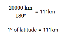
Any angular measurement from the earth’s centre to its surface represents certain latitude (Figures 3.13a and b). The distance from the North Pole to the South Pole is about 20000 kilometres, and there are 180º (half a circle) between them.
For example, the tropic of cancer is drawn on the surface of the Earth with an angular line of 23½º N measured anticlockwise from the equator. Latitudes are parallel to each other. They result into uniform width between them.
They have different lengths, decreasing from the equator towards the poles. Equator is the longest latitude at the centre of the Earth. Therefore, the distance on the earth’s surface between one latitude and the other must be equal to 111 kilometres.


Determining longitudes
A longitude is an imaginary line measured from east or west of the prime meridian. The angle of longitude is determined by measuring the angle from the centre of the earth along the equatorial plane, East or West of the prime meridian.
Since the world is about 40000 kilometres round at the Equator and there 360º in a circle, the distance between each degree of longitude at the equator must be:

Generally, when locating or finding position of a place using latitudes, you start with the latitudes followed by longitudes.
Activity 9
(a) Take the world map or globe, and find your country on it.
(b) Study the latitude and longitude to identify the position of your country.
Exercise 6
1. Explain the relationship between longitudes and time.
2. Why does the distance through the Equator from West to East differ from that measured from North Pole to South Pole?
3. Why are parallels different from meridians?
Great circles
A Great circle is any circle that divides the Earth into two equal spheres . The equator and the Greenwich Meridian are both great circles. Similarly, all other meridians are also great circles. The equator, on the other hand, is the only latitude that is a great circle.

Great circles are important in our daily life. They are used in navigation and aviation. They are used to plot shore routes for ships crossing the oceans to save fuel and time. In aviation, pilots use great circles to mark the shortest path. In general, great circles are the shortest routes between any two places far apart on the earth’s surface.
Importance of latitudes and longitudes
The usefulness of latitudes and longitudes are as follows:
(a) Latitudes determine climatic variations. For example, the temperature decreases from the Equator towards the poles.
(b) Longitudes are used to calculate local time of different places on the earth’s surface.
(c) They enable us to precisely identify any location on the Earth.
(d) They enable us to identify routes for aviation and navigation.
(e) They help in forming a grid system essential for mapping, and communication of geographic data worldwide.
(f) Longitudes are used to determine days and dates in the world with reference to the International Date Line.
(g) They help to determine distances between places on the earth’s surface.
Calculating local time using longitudes
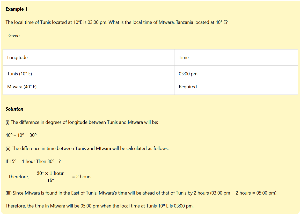
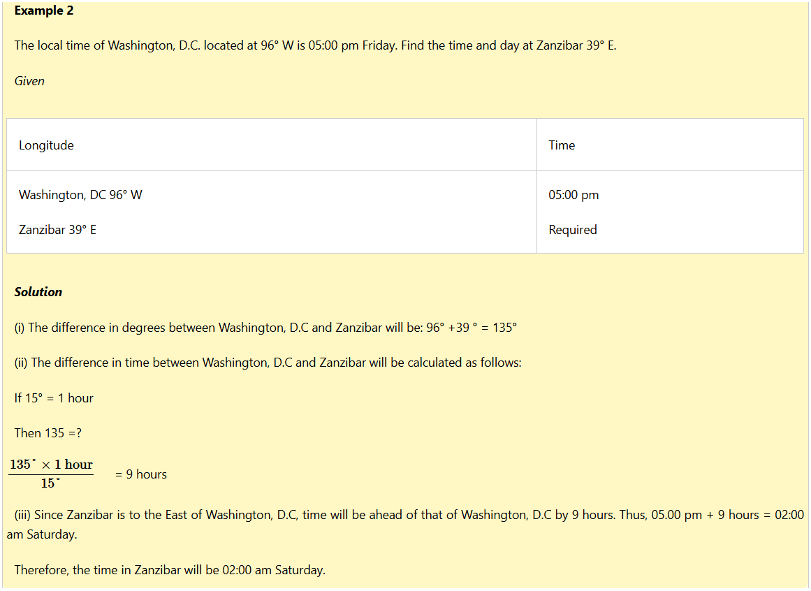
The Earth rotates on its own axis from West to East once after every twenty four hours (one day). This means that the Earth turns through 360° in 24 hours. It rotates 15° in one hour or 1° in 4 minutes.
All the places along the same longitude experience mid-day at the same time. For example, if it is 12:00 noon in Addis Ababa (39° E), it will also be 12:00 noon in Dar es Salaam as it is also located at 39° E.
On the contrary, places along different longitudes experience different times. For example, when it is 12:00 noon at places like Accra in Ghana or London in England located along the Greenwich meridian (0°), it will be 1:00 pm at all places along longitude 15°E or 11:00 am along longitude 15°W. While calculating time the following conditions should be observed;
(i) In calculating time, we use longitudes of given places.
(ii) When calculating time of two places located on the same side of the prime meridian, for example, East to East or West to West, you should find the difference in degrees by subtracting the degrees of the two places.
(iii) When calculating the time between two places located in different sides of the prime meridian, one on the East and the other on the West, you should add the degree of the two places. This is due to the rotation of the Earth on its axis. The more you move towards the East, the more time increases, while the more you move towards the West the more time decreases. The time recorded along the same longitude is known as Local Mean Time (LMT). Consider the following examples.

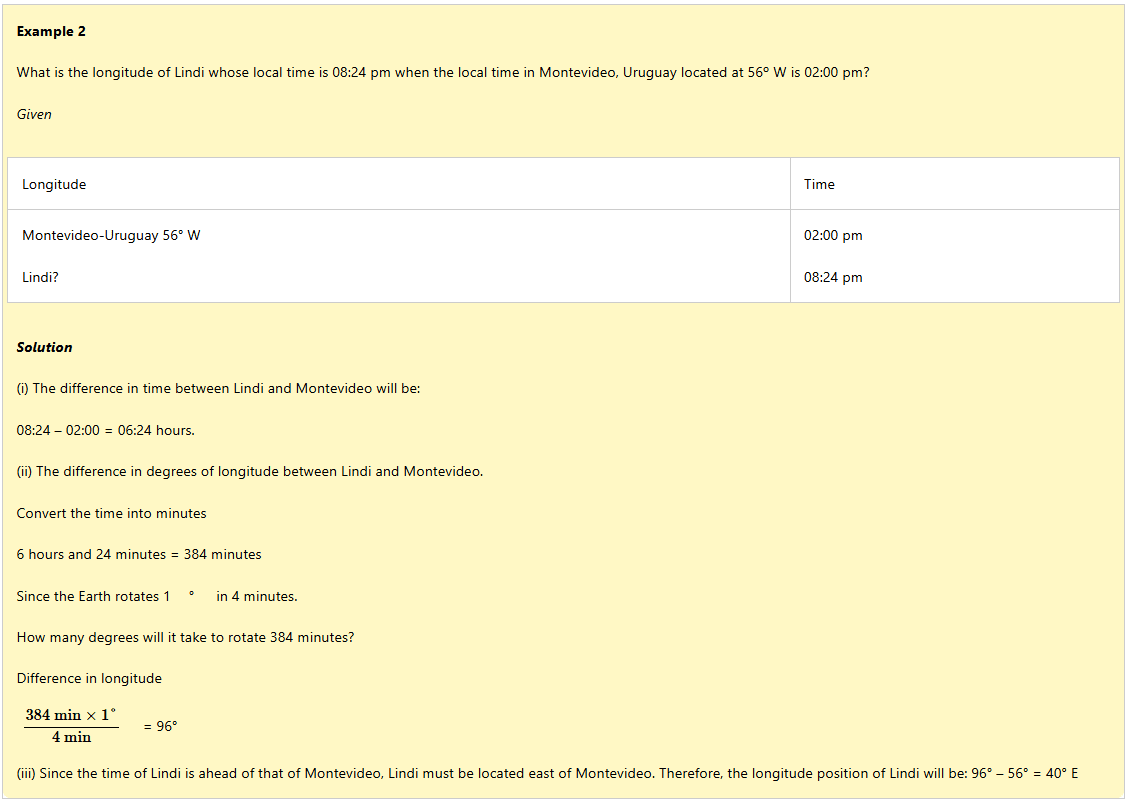
Calculating the longitude of a place using local time
The longitudes of places are calculated using their local time. Consider the following examples.
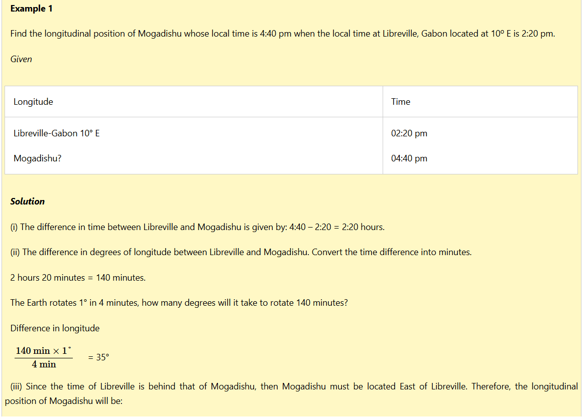
10° E + 35° = 45° E.
Time zones
A time zone refers to a stretch of land where the standard time is accepted throughout the longitudinal zone of 15° in width. The world is divided into 24 time zones, each approximately 15° longitude apart. There would be problems in telling time if every place had its own time set according to the Local Mean Time (LMT).
Essence of time and time zones
The essence of time zones resulted from difficulties in identifying time for a particular area. If each place across a country followed its own time, it would create confusion. For example, Dodoma is about 35° E and Tanga is about 39°E.
If each followed its own local time, there would be a difference of 16 minutes between the two towns. There would be confusion in railway and airways timetables or in radio programmes if they had different in times, each referring to its local area.
To avoid time confusion, different stretches of land take their time from agreed meridian. The time adopted is known as standard time. In East Africa, standard time is taken from the meridian of 45°E.
When the whole stretch of land keeps the same standard time and that stretch forms a time zone. The Greenwich Meridian is the starting point for dividing the globe into 24 time zones. The standard time for Greenwich is known as the Greenwich Mean Time (GMT).
Variation of standard time in a single country
Countries with large stretches of land, for example, Russia, the United States of America, Canada and China have several standard time zones for practical purposes.

The International Date Line
The International Date Line (IDL) is an imaginary line where date is changed or calendar day begins. This line is internationally agreed upon, and follows the meridian of 180° W (or E) longitude except where it crosses land surface. However, the IDL is not straight for the purpose of avoiding crossing land masses which would cause a country to have two different days at the same time.

Activity 10
Design a pictorial chart giving information of the important parallels and meridians of the Earth.
Exercise 7
1. Name the two most common great circles and explain their importance on the Earth.
2. Calculate the longitudinal position keep of town H whose time is 10:00 am, when it is 3:00 pm in Town G whose longitude is 5° W.
3. Calculate the longitudinal position of a town whose local time is 7:00 am while GMT is 5:00 pm.
4. Kalunde starts his trip at longitude 0° at 12:00 noon-moving towards town Y at longitude 45° E. Calculate the time that Kalunde arrives at his destination.
5. If the time in Town Z located at 75°W is 5:00 pm on Friday, calculate the time and day Town K located at 120° E.
Revision exercise
1. ‘The variation in daytime and night-time experienced throughout the day is caused by rotation of the Earth’. Explain.
2. Describe how movements of the Earth and moon relate in regard to the position of the sun.
3. What are the effects of perihelion and aphelion on our life?
4. Why all meridians are great circles?
5. Imagine you are at the beach during different times of high and low tide. What would you observe?
6. Calculate the local time in New York (USA) located at 75° W, when it is 10:00 am in Lagos, Nigeria located at 15° E.
7. What is the time at 120° E when it is midnight at Greenwich?
8. If it is 4:15 am in a Village A located at 20° E, calculate the local time of a Village B located along the following longitudes:
(a) 50° E (b) 65° E (c) 75° E (d) 90° E
9. If the time at town A located along the meridian 40° E is 10:00 am, calculate the time along the following meridians:
(a) 55° W (b) 10° W (c) 60° W (d) 0°
10. If the time of town B located at 120° E is 12:00 (noon), calculate the longitude of the following recorded times:
(a) 5:30 pm (b) 5:30 am (c) 12:00 noon (d) 3:45 pm