Major Features of The Earth’s surface
People live on the earth’s surface, which hosts a variety of features and serves as the primary habitat for all forms of life. The existence of land, water, and vegetation plays a central role in sustaining human and other living organisms on our planet.
In this lesson, you will learn about major features of the earth’s surface such as continents and their features. You will also learn the major water bodies such as oceans and seas, major features of the ocean floor, as well as large inland water bodies such as rivers and lakes.
Moreover, you will learn about vegetation zones on the earth’s surface and their importance to human life. The competencies developed will enable you to use and manage resources sustainably in different places.
Earth’s surface
Activity 1
(a) Observe the appearance of your school compound and the nearby areas.
(b) Analyse the features that you have observed and note them down.
Earth’s surface refers to the outermost layer of the Earth, including both the landmasses (continents and islands) and the water bodies (oceans, seas, lakes, and rivers). It is the part of the Earth that we interact with directly and where all terrestrial life exists.
It is made up of continental landmasses, which cover about 29% of the earth’s surface, and water bodies, which cover about 71% of the earth’s surface. The landmasses comprise of continents and vegetation. The water bodies consist of oceans and seas, and large inland water bodies such as rivers and lakes.

Continents and oceans of the world
Activity 2
Explore information from library and other reliable online sources about the continents of the world, focusing on their cultural diversity, climate, geographical features, and significant historical events.
In the beginning the earth’s surface was a single giant landmass called Pangaea that was surrounded by a single superocean called Panthalassa. Over millions of years, the geomorphic processes caused the Pangaea to break up into two big landmasses. The northern landmass was called Laurasia, and the southern landmass was called Gondwana.
The two landmasses were separated by Tethys Sea. The two supercontinents broke into present continents whereby Laurasia included present-day North America, Europe, and Asia while Gondwana comprised of present-day Africa, South America, Antarctica and Australia.
A continent is a major landmass rising from the ocean floor. Continents are usually surrounded by a large mass of water bodies such as oceans and seas. Islands adjacent to continents are part of them because they contain rock structure similar to that of the continent.
In general, there are seven continents on the Earth, namely: Asia, Africa, South America, North America, Australia, Europe and Antarctica (Figure 4.1). Among the seven continents, five continents are separated by oceans and seas, except Europe and Asia, which are separated by the Ural Mountains.

Activity 3
(a) Prepare a well labelled sketch map of a world showing the seven continents.
(b) Give at least one fact about the continent identified, including the name of a country or a major city located on the continent.
The continents of the world are arranged by size starting with the largest to the smallest. They can also be arranged from the smallest to the largest continent depending on the purpose. Therefore, the following is the description of continents based on the size from the largest to the smallest.
1. Asia
Asia is the largest continent. It covers more than one third of the land surface of the Earth. It is about 1.5 times the size of Africa. Its total area is 44.6 million square kilometres.
The continent of Asia stretches from 10° S to 78° N and from 30° E to about 180° E. The continent is bordered to the North by the Arctic Ocean, to the East by the Pacific Ocean and on the South by the Indian Ocean.
To the West the Ural Mountains form the boundary between the continents of Asia and Europe, while to the South West, the continent is bordered by Africa and separated by the Red Sea.

2. Africa
Africa is the second largest continent in size with an area of about 30.3 million square kilometres. Africa extends from 35°S to 37°N and from 15°W to 50°E. About three quarters of the area lies in the tropics. Africa is the only continent crossed by the three tropics. The continent is crossed by the Equator, the Tropic of Cancer, and the Tropic of Capricorn.
Africa is bordered by the Mediterranean Sea to the North, the Atlantic Ocean to the West, the Indian Ocean to the East and the Southern Ocean to the South. Islands such as Madagascar, Seychelles, Comoro, Unguja, Pemba, Mafia, and Mauritius in the Indian Ocean, and the Canaries in the Atlantic Ocean are part of the African continent.

3. North America
North America is the third largest continent in size with an area of about 24.7 million square kilometres. It extends from 10°N to 80°N and from 60°W to 160°W. The continent is bordered by the Pacific Ocean to the West, the Atlantic Ocean to the East, and by the Arctic Ocean to the North. To the South, it is bordered by the continent of South America.

4. South America
South America is the fourth largest continent in size, about half the size of Africa. Its area is about 17.8 million square kilometres. It lies between 10° N and 50° S and between 35° W and 80° W.
The Atlantic Ocean borders this continent to the East and the Pacific Ocean to the West. It is separated from the continent of North America by the Panama Isthmus.

5. Antarctica
Antarctica is the fifth largest continent in size, and it is about one-third the size of Africa. Its area is about 14 million square kilometres. It is located around the South Pole and almost all of it lies within latitude 66° S.
It is surrounded by the Southern Ocean. It is not inhabited by human beings because of the extreme low temperature below freezing point throughout the year.

6. Europe
Europe is the sixth largest continent in size, and it is about two-fifth the size of Africa. It has an area of 10.1 million square kilometres. The continent of Europe lies between 40° N and the Arctic Circle and between 10° W and 60° E. It lies to the West of the continent of Asia.
The Ural Mountains separate Europe from Asia. To the North, it is bordered by the Arctic Ocean, to the West by the Atlantic Ocean, and to the South by the Mediterranean Sea.

7. Australia
Australia is the smallest continent, and it is about a quarter of the size of Africa. It is about 8.5 million square kilometres. Australia lies approximately between 10° S and 40° S and 115° E and 150° E.
The islands of New Zealand, in the Southeast of Australia, are part of the continent. The continent is bordered by the Indian Ocean to the West and the Pacific Ocean in the North. In the East and South, it is bordered by the Southern Ocean.

Exercise 1
SECTION A:
Fill in the blanks with the correct names of the continents of the world
1. The largest continent, both in terms of land area and population, is. __________.
2. __________ is recognised as the smallest continent, and it is commonly referred to as the “island continent.”
3. __________ is the only continent that lies in both the Northern and Southern Hemispheres.
4. The continent that is located entirely in the Southern Hemisphere and covered mostly by a massive ice sheet is __________.
5. __________ is the continent where you can find the Sahara, which is the world’s largest hot desert.
6. The continent with countries such as Canada, United States of America (USA), and Mexico is __________.
SECTION B:
Answer the following questions
1. Give a short description of how continents were formed.
2. Describe the geographical features of Africa.
3. Which continent do you currently reside in? Describe its geographical location.
4. Provide five benefits of geographical position of Tanzania within its continent.
Interaction between continental landmasses and water bodies
Some continental landmasses interact with water bodies. This interaction results in the formation of different features like gulfs, capes, peninsulas, Isthmus and straits. A gulf is a part of the ocean that penetrates a landmass.
Examples of gulfs are the Persian Gulf (Western Asia), the Gulf of Mexico, the Gulf of Bengal and the Gulf of Guinea. A strait is a narrow water path that separates landmasses. Examples of straits are the Strait of Gibraltar (Morocco), Luzon Strait (Taiwan), and Makassar Strait (Indonesia).
A cape is a pointed or narrow extension of land entering into a body of water such as ocean, sea, lake or river. Examples of capes are the Cape of Good Hope in South Africa, Cape Horn in Chile, and Cape Leeuwin in Australia.
Peninsula is a landmass that is almost surrounded by water but still connected to the mainland. It is large than a cape. Examples of peninsulas are Msasani in Tanzania, Arabian, Alaskan and Indo-China. Isthmus is a narrow land stretch that joins two major land masses. Examples of isthmus include the Isthmus of Panama between Nicaragua and Colombia and the Suez between Africa and Asia.

Activity 4
Carefully study the world map in Figure 4.2 and do the following:
(a) Identify major gulfs, capes, peninsulas, Isthmuses, and straits on each continent.
(b) Give the importance of each feature you have identified in (a) above.
Major relief features of the continents
Each continent has its unique geographical features. The surface of any continent is not regular in shape and elevation. The height above the sea level (altitude) and slope (degree of steepness of the land) give rise to different relief features.
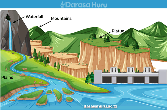
In this regard, the main relief features of the continents include Plains, plateaus, mountains, and basins. Other relief features include hills and valleys. The following Figure shows the major relief features of the continents.

Plains
Plains are continuous stretches of comparatively flat lands that do not change much in elevation. For example, the Serengeti plains of Tanzania, Siberia in Asia, North European plains, Indo- Gangetic plains in India, and the Great Central plains of North America.
Many extensive plains result from down warping of the earth’s crust. Plains found along coastal areas are known as coastal plains. These include the coastal plains of Tanzania, Kenya and Mozambique.
Plateaus
A plateau is an extensive high altitude area with more or less uniform summit level. Plateaus significantly rise above the surrounding area with one or two sides with steep slopes.
Plateaus are formed when forces from within the Earth uplift a large land area. Uplifted areas of level or undulating land form plateaus, sometimes called tectonic plateaus.
When an uplifted area slopes down to sloping lower land, it is a table land. South African, Arabian, and Spanish plateaus are examples of table land. Some plateaus are formed following successive flow of lava, erupting from the interior of the Earth.
Such plateaus are known as lava plateaus. Examples include the Deccan plateau in India, Columbia and Snake plateau in the United States of America. Plateaus, which are surrounded by a higher land adjoining mountain, are called intermontane plateaus.
Examples of intermontane plateaus are Bolivian and Tibetan plateaus that lie between fold mountain ranges of the Andes in South America, Kunlun Shan and the Himalayas in Asia.
Mountains
A mountain is part of the earth’s surface that rises abruptly to a greater height, usually above 300 metres from the surrounding level. There are four major types of mountains.
These are Fold Mountains, Block Mountains, volcanic mountains, and residual mountains. These mountains are categorised based on the way they were formed.
(a) Fold mountains
Fold Mountains are features formed mainly by the process of folding or wrinkling of the upper parts of the earth’s crust due to compressional forces. Major Fold Mountains in the world include the Himalayas in Asia, the Rockies and Appalachians in North America, and the Andes in South America. Others are the Alps in Europe, the Atlas in North Africa, and Cape ranges in South Africa.

(b) Block mountains
A Block Mountain (horst) is an upland area with a table-like structure bordered by faults on one or both sides. It is formed when tensional or compressional forces in the crust force layers of crustal rocks to break, resulting in central part being uplifted.
Examples of Block Mountains are the Uluguru and Usambara in Tanzania, and Ruwenzori in Uganda (East Africa), the Vosges and Black Forest Mountains in Europe, and Mount Sinai in Asia.

(c) Volcanic mountains
When rocks are under intense heat and pressure in the earth’s crust they melt and form magma. When the magma inside the earth’s crust finds a weak point in the earth’s crust, they erupt and molten rock flows out as lava.
When it cools, it forms a cone. Volcanic Mountains are cone-shaped mountains formed from the cooling and solidification of hot molten rock material (lava) from the interior of the Earth during a volcanic eruption. There are three main types of Volcanic Mountains, depending on the frequency of eruption and the types of lava.
Active volcano mountains are the ones which experience periodic eruptions. For example, Oldonyo Lengai in Tanzania, Vesuvius in Italy (Figure 4.6 a), Nyiragongo in the Democratic Republic of Congo, and Mauna Loa in Hawaii. Volcanic Mountains, which erupted only once in historical times, are referred to as dormant volcanic mountains, since they are no longer active.
Examples include Mount Kilimanjaro in Tanzania (Figure 4.6 b), Mount Ararat in Turkey, Fuji and Mauna Kea in Hawaii. Volcanic Mountains, which have not erupted for a very long time and have not shown any sign of eruption, are known as extinct or dead volcanic mountains. Examples include Mount Rungwe in Tanzania, Mount Kulal in Kenya, and Mount Chimborazo in Ecuador.

(d) Residual
Residual Mountains are formed because of weathering and erosion of weaker rocks of the already existing mountains, leaving behind resistant rocks (Figure 4.7). The remaining resistant rocks are known as residual mountains or mountains of denudation.
Examples of residual mountains include the Sekenke Hills of Singida in Tanzania, the Ahaggar Mountains of Central Sahara and the Adamawa Mountains of Eastern Nigeria.

Rift valleys
A rift valley is a long narrow deep and steep-sided depression between parallel faults on the earth’s surface. They are formed through tensional or compressional forces when the ground between two parallel faults sinks. The walls of rift valleys form escarpments, which is an elongated steep slope at the edge of an upland area and gentle slope on the other side.
The Great East African Rift Valley is the longest valley in the world. It stretches from Jordan, through the Red sea, Ethiopia, Kenya and Tanzania to lower Zambezi in Mozambique. In East Africa, the Great African Rift Valley has two arms, namely the eastern arm and western arm.
The eastern arm is occupied by lakes Turkana, Magadi, Eyasi, Natron and Manyara. The western arm is occupied by lakes Nyasa, Rukwa, Tanganyika, Kivu, Albert and Edward (Figure 4.8). Another rift valley is the Rhine valley, which is found between the Vosges Mountains in France and Black Forest mountains in Germany.

Basins
A basin is a natural depression or bowl-shaped hollow on the earth’s surface, formed when part of the land sinks due to earth’s movements. These basins vary in size, with some occupied by water.
Basins collect water and sediments from surrounding land surfaces. Some of the basins are found in oceans (ocean basins) or in seas (sea basins) or in lakes (lake basins).
Other basins are found higher above sea level and are surrounded by mountains. Basins situated above sea level are drained by rivers and their tributaries are called river basins.
These river basins include the Congo River Basin in Africa and the Amazon Basin in South America. Lakes such as Victoria in Tanzania and Kyoga in Uganda are examples of basins occupied by water.
Exercise 2
1. With examples explain the economic and social importance of the following relief features to the community:
(a) Mountains
(b) Plains
(c) Plateaus
(d) Basins
(e) Hills
(f) Valleys
2. Explain how a rift valley differs from other valleys.
3. With examples, describe the processes of mountain formation.
4. Describe human activities on mountains.
Water bodies on the earth’s surface
A water body is a mass of stationary or moving water which occupy the surface of the Earth. Water bodies can be salty or fresh, large or small. Water occupies about 71 percent of the earth’s surface. There is more water surface in the southern hemisphere than in the northern hemisphere. Some of the major water bodies are rivers, lakes, seas, and oceans.
Rivers
A river is a mass of fresh water flowing by gravity in a definite channel from the source to the mouth. The source of a river may be rainfall, natural spring, melting glacier, marshland, or lake. A river can also originate from underground aquifers.
These sources are the starting points of a river flow; they feed water into the river’s channel, which eventually forms a stream, which drains its water towards a river mouth. The river’s mouth is a point where the river discharges its water into the ocean, sea, lake or swampy area.
In Tanzania, the major rivers are Rufiji, Ruvuma, Kagera, Pangani, Malagarasi, Ruaha, Wami and Ruvu (Figure 4.9). Major rivers in Africa include the Nile River (6,650 km long), the largest river in the world and the Congo River (4,700 km long).
River Nile originates from Lake Victoria basin and discharges its water into the Mediterranean Sea. Other major rivers in the world are the Amazon River (South America) 6,400 km long, the Mississippi River (North America) 6,275 km long, and Yangtse River (Asia) 6,385 km long.

Lakes
A lake is a hollow or depression in the earth’s surface that contains fresh or salty water. Example of lakes in Tanzania includes Victoria, Tanganyika, Nyasa, Rukwa, Manyara, and Eyasi. All these lakes, except Victoria are rift valley lakes.
Lake Victoria is a basin lake. Some lakes are so large that they are called seas. Examples of such lakes are the Caspian Sea, Dead Sea, and the Aral Sea. Although most lakes are permanent, few of them are temporary depending on climatic variations.
Some lakes are natural whereas others are man-made. For example, in Tanzania, natural lakes include Lake Victoria, Tanganyika, Nyasa, Rukwa and Manyara while man-made lakes include Lake Kidatu, Mtera, Kihansi, and Tipe.
Lake Superior in North America is the world’s largest fresh water lake followed by Lake Victoria in East Africa. Lake Baikal in Russia is the deepest fresh water lake in the world followed by Lake Tanganyika found in Tanzania.

Exercise 3
1. Assume that you are to organise an African festival about lakes and rivers of Tanzania. What activities and cultural events would you include to showcase the importance of lakes and rivers to local people?
2. If Tanzania did not have major inland water bodies, what could have been the disadvantages?
3. Suggest possible alternative sources of water that could be used in the absence of major inland water bodies.
Activity 5
(a) Choose one major water body in Africa with regard to Tanzania and East Africa.
(b) Prepare information cards or posters of such a water body, including the name of the water body and interesting feature or characteristics of the water body, and thereafter illustrate the water body on the card or poster.
(c) Explain how oceans interact with other water bodies on the planet Earth.
Seas
A sea is a large body of salty water that is surrounded in whole or in part by land. Examples include the Mediterranean Sea, Red Sea, South China Sea, Sea of Japan, and Yellow Sea.
The salinity of a sea depends on the temperature and the amount of fresh water from rivers and melting of ice that is discharged into it. High temperature causes high evaporation that increases the salinity, whereas the addition of fresh water decreases salinity due to dilution.
Very high salinity occurs in inland seas such as the Dead Sea because of high evaporation and very little input of fresh water that enters them. The Baltic Sea in Europe has very low salinity because several large rivers discharge into it, evaporation is low, and fresh water is added by melting ice and snow. The seas around the poles generally have low salinity because of low evaporation and addition of water from melting ice.

Oceans
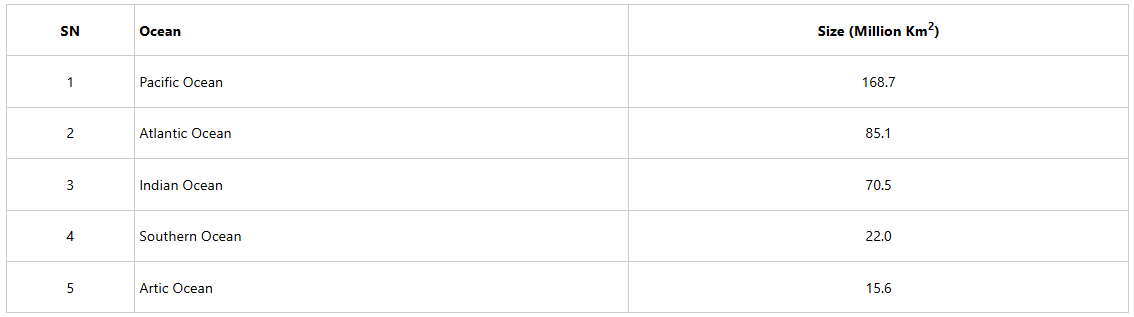
An ocean is a large body of salty water surrounding the landmass of the Earth. The major oceans of the world are the Pacific, Atlantic, Indian, Southern and Arctic Oceans.

The oceans of the world with their relative sizes are shown in Table 4.1. The Pacific Ocean is the largest in size whereas the Arctic is the smallest ocean in size.
Relative sizes of the world’s major oceans
Exercise 4
1. What is the difference between an ocean and a sea?
2. What determines the salinity of oceans and seas?
The ocean floor and its features
Ocean floor (sea-bed) refers to a landscape found at the bottom of the ocean. The ocean floor is made up of various features. The major features of the ocean floor include the continental shelf, the continental slope, oceanic ridges, deep sea plain, ocean deep (trench), ocean plain, oceanic island, and submarine plateaus.

Continental shelf
A continental shelf is a gently sloping margin of a continent that is occupied by shallow waters that extend from the coastline to a depth of about 200 metres towards the continental slope.
Some continental shelves provide excellent fishing grounds in the world because they are shallow, and they allow the sun’s rays to reach the shelf floor. Hence, they provide good conditions for the growth of plankton, which fish feed on.

Continental slope
A continental slope is found at the point where the continental shelf forms a steep slope towards the ocean basin.

Mid-ocean ridge
A mid-ocean ridge is a raised part of the ocean floor. Some of these ridges appear above the surface of the ocean as oceanic islands such as Azores in Portugal and Bouvet in Norway. Examples of the mid-oceanic ridges are the Mid-Atlantic Ridge in the Atlantic Ocean and the Mid-Indian Ridge in the Indian Ocean.

Deep sea plain
Deep sea-plains are extensive undulating areas of the ocean floor. It is also known as abyssal plains. Large parts of these plains are covered by thin layers of sediments of both organic and inorganic materials brought in by rivers and some from broken rocks of the ocean floor and cliffs.

Abyssal hill
Abyssal hill are small sharp hills rising from abyssal plain surface.

Ocean deep
An ocean deep (trench) is a long narrow steep sided depression plunging from the deep sea-plain to the depths of 10000 metres or more. The deepest known ocean trench in the world is Mariana Trench, which is approximately 11000 metres deep. It is located 11035 metres off the Island of Guam in the Pacific Ocean.
Island
An island is a piece of land surrounded by water. Islands may occur in oceans, seas, lakes or rivers. A group of islands is called an archipelago. Examples of an archipelago include Islands of Zanzibar and the Comoros.

There are three types of islands: continental islands, oceanic islands, and coral islands.
(a) Continental islands
A continental island is a large unbroken landmass similar to a continental landmass rising from a continental shelf. Examples of continental islands include Mafia, Pemba, Unguja, Philippines, Indonesian, Greenland, and Sri Lanka.
(b) Oceanic islands
Oceanic Islands rise directly from the ocean floor. Some of the oceanic islands are the tops of oceanic ridges, plateaus, and ocean floor volcanoes. Examples of oceanic islands are Hawaii, Cape Verde, Iceland, Canary, and Seychelles.
(c) Coral islands
A coral island is an island, which is built up from limestone rocks made of skeletons of very small marine organisms called coral polyps. Examples of coral islands are the Maldives, Aldabra, Bermuda, and St. Martines Islands.
Activity 6
Study the world map showing major rivers. Then, do the following:
(a) Identify and locate major oceans, seas, and lakes.
(b) Identify the respective countries through which the Nile, Congo, and Amazon rivers flow.
(c) Where do rivers in (b) empty their water?
Vegetation
Vegetation refers to a community of plants, trees, shrubs, grasses, mosses, ferns, and other green species that grow in a particular area. Vegetation gives an area a distinct character. It forms the natural landscape of a place.
It is an important feature that forms an essential part of the earth’s surface. Vegetation supports various animal species, maintains ecological balance, and contributes to the overall health of the environment through temperature regulation, rain formation and soil protection against erosion.
Types of vegetation
The vegetation on the surface of the Earth can be categorised into natural vegetation and planted vegetation. The main vegetation cover of the earth’s surface is forests and grasslands. Such forests and grasslands are made of plants, trees, shrubs, grasses, and other green vegetation species.
Moreover, some vegetation occupies the water bodies and is referred to as aquatic vegetation. The aquatic vegetation consists of plant species such as algae or seaweed, duckweed, and other marsh, or mangrove vegetation. However, much of the world’s landmass is covered by grasslands.
(a) Natural vegetation
Natural vegetation refers to vegetation that grows in a particular region without direct influence of human beings. It grows under natural physical conditions that have not been disturbed by people. The vegetation adapts to the specific environmental conditions of the place. Natural vegetation includes woodlands, forests, grasslands, desert vegetation and swamp vegetation.
Woodlands
Woodlands are wide regions covered by open and low-density trees. Woodlands are habitat of different plant species and animals. Examples of woodlands in Tanzania include the Miombo woodlands found in Tabora and Ruvuma regions.
Forests
Forest refers to a large area of land covered predominantly with tall trees and other woody vegetation, creating a dense and extensive ecosystem (Figure 4.12). In Tanzania, most of these natural forests have been designated as forest reserves, national parks or game reserves. These include natural forests of Uluguru, Usambara, Udzungwa, Gombe, Selous, and Rubondo.

Grasslands
Grassland vegetation refers to a type of vegetation dominated by grasses. It also includes other herbaceous plants. In grassland vegetation, trees and shrubs are relatively sparse or absent.
Grasslands vegetation is widespread, it is found on every continent including Antarctica where tussock grass may be found. In Tanzania three major grasslands are Serengeti plains, Kitulo grassland, and Maasai steppe. Serengeti plains and Maasai steppe are famous for wildlife, while Kitulo grassland is famously known as the Serengeti of flowers.


Swamp vegetation
A swamp is a wetland with woody vegetation (Figure 4.14). Swamps are waterlogged environments which may be characterised by standing water, shallow or slow-moving water, and waterlogged soils.
They are home to a variety of plant species adapted to these unique conditions, including emergent plants, floating plants, submerged plants, trees like mangroves, shrubs, mosses, and ferns.

Desert vegetation
This is a type of vegetation found in desert areas. A desert is an area of land with little or no vegetation cover (Figure 4:15). The area receives very little rainfall, which causes few plants and animals to adapt and survive in such condition.
Plants adapted to desert and semi-desert conditions include scrub and cactus. In Tanzania semi desert vegetation is found in the central part of the country.

(b) Planted vegetation
Planted vegetation is also known as artificial vegetation or man-made. It refers to vegetation that is entirely grown by man and does not occur naturally in the environment.
Unlike natural vegetation, planted vegetation is intentionally planted or made to serve specific purposes. Different areas in Tanzania have planted vegetation for different purposes. Such areas include Mufindi, Makete, Lushoto, Rongai, Buhindi, and Njombe, where soft wood forests have been established.
Distribution of the world vegetation
Vegetation of the world is distributed according to vegetation zone. There are six main vegetation zones distributed in different parts of the world, namely: tundra or polar, temperate, desert, tropical, Mediterranean, and mountain vegetation. Areas covered with water are occupied by aquatic vegetation. Figure 4.16 show the distribution of the world’s vegetation.

Activity 7
(a) Study the world map on the distribution of vegetation and identify the variety of vegetation found in different vegetation zones.
(b) Describe the economic activities carried out in forest areas.
Factors influencing the vegetation zones of the world
The distribution of the vegetation zones across the world is influenced by a combination of various factors. These factors interact in a complex way to determine the types of plants that can thrive in a particular region, resulting in the diverse array of the vegetation zones observed across the world.
Understanding these factors is crucial for studying and conserving different ecosystems and their plant communities. The main factors influencing distribution of vegetation in the world include climate, soil, topography, and biotic.
1. Climatic factor
Climate is the average weather condition of a place observed and recorded over a long period of time, usually over 30 years. It is one of the most significant factors affecting the distribution of vegetation zones. Sunlight, temperature, precipitation, and wind play crucial roles in determining the types of vegetation that can grow and survive in a particular area.
(a) Temperature
Influences the length of the growing season and the ability of plants to survive in extreme cold or hot environment. For instance, tropical rainforests thrive in regions with consistently high temperatures.
In mountain areas, as elevation increases, temperatures generally decrease, leading to changes in vegetation zones similar to those seen with changes in latitude towards the poles.

(b) Precipitation
The amount and distribution of precipitation are critical factors affecting the types of vegetation growing in an area. Areas with high and consistent precipitation tend to support dense forests, while regions with low and irregular precipitation are more likely to have sparse grasslands or desert vegetation.
For instance, areas that receive heavy and well distributed precipitation throughout the year have dense forests with different tree species. Typical examples are the Congo and Amazon basins. Areas with moderate or low and seasonal rainfalls are dominated by grasslands and scattered woodlands.

(c) Sunshine
Sunshine is the primary source of energy for photosynthesis, the process by which green plants use sunlight to manufacture their food. The availability of sunlight directly affects the rate of photosynthesis, which, in turn, influences the growth and distribution of vegetation.
The availability of sunshine is therefore, critical because it influences the distribution of vegetation across the world. It affects plant growth, photosynthesis and the types of plant communities that can thrive in a particular area.

(d) Wind
Wind is air in motion. Usually air moves from high pressure areas to low pressure areas. Wind plays a crucial role in shaping vegetation growth, distribution, and adaptation.
For example, in areas with strong and persistent winds, vegetation may experience wind trimming or pruning. Strong winds also cause the trees to bend. Strong winds can break branches, remove leaves, or damage vegetation structure.
Over time, this can lead to unique growth patterns. In addition, winds can be moist or dry. The moisture content of the winds influences plant growth. Hot dry winds accelerate water loss from the plants and weaken the growth of vegetation.

2. Topographical factors
Topography is the altitude or elevation of an area. Topography includes factors like relief, slope, and aspect, which can create microclimates that influence the types of vegetation present in an area.
(a) Relief
This refers to the difference in elevation between two or more points on the earth’s surface. The height of the land determines temperature and rainfall. As the altitude of an area increases, the microclimate changes, leading to the formation of different vegetation zones. This is distinct on mountains. The vegetation ranges from grass to forests, bamboo, heath and moorland.

(b) Slope
Steep slopes experience high rates of soil erosion leading to the development of thin and shallow soils. This results in poor plant growth. Gentle slopes have deep and well drained soils, resulting in the growth of vegetation.

(c) Aspect
Aspect is the orientation or direction of the slope toward sunshine and rainfall. Normally, the side of a slope exposed to the sun is warm; hence, it supports plant growth. Less vegetation grows on the slopes which are not exposed to sunshine.
For example, in the northern hemisphere, north-facing slopes may receive less sunlight and have different plant communities than south-facing slopes and vice versa in the southern hemisphere.

3. Edaphic factor
Soil is one of the most important ecological factors called edaphic factor. The type and quality of soil in an area determines the type of vegetation found in that area. Some plants are adapted to specific soil types, while others can tolerate a broader range of soil conditions.
The soils, that are deep and well drained support growth of vegetation. Such soils favour growth of large trees and thick forests. Areas with shallow soils hardly support the growth of large and long rooted trees but can support shrubs and grasses. Soils with a lot of nutrients and humus support growth of vegetation than soils without or with low nutrients or humus.

4. Biotic factor
Human activities can develop or destroy vegetation of an area. Human practices such as agroforestry, reforestation, afforestation, and creation of forest reserves result in the development of vegetation.
However, human activities such as urbanisation, agriculture, and the introduction of invasive species alter vegetation types. Also, deforestation, mining, and overgrazing destroy vegetation.
Moreover, some animals, birds, and insects aid in pollination and seed dispersion, leading to the growth and distribution of vegetation on the earth’s surface. For instance, burrowing animals and earthworms create suitable conditions for plant growth, by aerating and fertilizing the soil.

Activity 8
(a) Study the vegetation zones found in Tanzania by consulting the library and internet sources.
(b) Observe the vegetation found in the school and the nearby surrounding area.
(c) Draw the map of Tanzania and show the main vegetation zones found.
Importance of vegetation to human life
Vegetation plays a crucial role in supporting human life in a variety of ways. Its importance spans environmental, economic, social, and health aspects. Here are some key points highlighting the significance of vegetation to human life:
1. Production of oxygen
Through the process of photosynthesis, plants give out oxygen, which is essential for the respiration of living things including human beings. A large amount of earth’s oxygen is generated by plants, making them vital for our survival.
2. Helps in carbon dioxide absorption
During the process of photosynthesis, plants use carbon dioxide to manufacture their own food. Therefore, vegetation helps to regulate the earth’s climate by absorbing carbon dioxide, which is a greenhouse gas. This gas absorbs outgoing radiation and re-emits it, thus causing global warming. Basically, plants act as carbon sinks, reducing the impacts of climate change.
3. Source of food
Plants are the primary source of food for humans and other animals. A diverse range of fruits, vegetables, grains, and other plant-based products provide essential nutrients for human health and growth.
4. Help to control soil erosion
Vegetation holds the soil together and prevents erosion by water and wind. Roots of vegetation hold soil particles together. This helps to reduce soil erosion and conserve soil. Vegetation cover reduces the speed of surface runoff which can cause soil erosion.
5. Source of medicine
Many plant species have medicinal properties. Traditional medicine heavily relies on plant-based medicine. Pharmaceuticals and medical research also use plants to develop new drugs for treatment of various diseases.
6. Source of income
Agriculture and forestry which, heavily rely on vegetation, are major contributors to the national and global economy. The cultivation of crops, timber production, and the harvesting of various plant-based products provide employment and income for millions of people.
7. Habitat and biodiversity
Vegetation provides a habitat for numerous animal species, hence, supporting biodiversity. Conserving plant life is essential in maintaining a balanced and healthy ecosystem that sustains all living organisms, including humans.
8. Climate regulation
Forests, in particular, play a significant role in regulating local and global climates. They influence rainfall patterns, regulate temperature and act as a wind break, as well as a carbon sink.
9. Aesthetic and recreational value
Green spaces and lush landscapes contribute to the aesthetic appeal in urban and rural areas, providing recreational spaces for leisure activities, which can positively impact mental health and overall well-being.
10. Purifying air
Vegetation filters and purifies the air by removing pollutants and particulate matter, contributing to cleaner air for human beings to breath.
11. Improving soil fertility
When vegetation dies and decomposes, it adds organic matter to the soil hence improving the soil fertility. Organic matter also improves the soil structure, soil texture, water retention capacity and increases soil nutrients. This is crucial for agricultural productivity and in preventing landslides and other natural disasters.
12. Source of fuel
Currently many communities use fuel wood as a source of energy. The use of firewood and charcoal contributes to degradation of vegetation. Efforts are being made to help communities to use environmental friendly energy sources like electricity, natural gas and solar energy. Also, there are efforts being made to encourage the use of fuel efficient stoves that use small amount of wood fuel.
13. Source of building materials
Vegetation provides thatching materials and building poles for houses. Also, vegetation is a source of timber for construction and other uses.

Despite the importance of vegetation to human life and the environment, humans still contribute in degrading the environment and ultimately contributing to climate change.
For instance, human activities affect vegetation hence contributing to climate change. Such activities include deforestation, poor agricultural practices, production of charcoal and unsustainable timber harvesting.
Other human activities that cause climate change include inadequate alternative sources of energy for cooking and lighting, poor industrial and mining practices. These activities result into rising temperatures, decreased precipitation, and increase in the frequency and severity of extreme weather and climate events, such as strong winds, floods, and droughts. These events cause reduction of carbon sink, and affect socio-economic and biological wellbeing of people.
Currently, Tanzania in particular, climate change is responsible for more than 70% of all natural catastrophes, which are connected to persistent droughts and floods. In response to this however, various measures can help reduce carbon dioxide through encouraging forest conservation, tree planting, the use of energy saving stoves, conservation agriculture, and the use of renewable energy in industries.
Exercise 5
1. Explain the role of water bodies in the distribution of vegetation zones in Tanzania
2. Explain how topography and climate in Tanzania give rise to different vegetation zones
3. Why do we have different economic activities related to vegetation in different parts of Tanzania?
4. What economic activities related to vegetation zones can be conducted in places like Lushoto, and the Southern highlands in Tanzania?
5. What would have happened if Tanzania did not have the vegetation covers found in Serengeti, Ngorongoro, Manyara, and Mikumi national parks?
6. Why is vegetation important to human kind?
Revision Exercise
SECTION A:
For each of the question 1-7, circle the most correct answer from the options given.
1. Which of the following is an example of a major fold mountain in the world?
(a) The Himalayas in Asia
(b) Ruwenzori in East Africa
(c) Vosges and Black Forest in Europe
(d) Sekenke in Tanzania
(e) Kilimanjaro in Tanzania
2. From the following pairs of mountains, which one represent block mountains:
(a) Himalaya and Vosges
(b) Alps and Usambara
(c) Alps and Andes
(d) Uluguru and Usambara
(e) Kilimanjaro and Vesuvius
3. Which of the following is an example of residual mountains?
(a) Sekenke hills in Singida
(b) Kibo in Kilimanjaro
(c) Uluguru in Morogoro
(d) Usambara in Tanga
(e) Meru in Arusha
4. Dormant volcanic mountains are those which:
(a) Have never experienced eruptions
(b) Have erupted once but are no longer active
(c) Continue to erupt occasionally
(d) Erupt only when there is an earthquake
(e) Erupt every year
5. What is the primary force contribution to the formation of fold mountain.
(a) Volcanic activity
(b) Earthquakes
(c) Compressional forces
(d) Erosion
(e) Tensional force
6. Which of the following factors is crucial for the formation of block mountains?
(a) Hotspot activity
(b) Erosion
(c) On-going volcanic eruptions
(d) Tensional forces
(e) Compressional force
7. Rocks in the earth’s crust often have alternating layers of different types. What is the name of these layers?
(a) Isostasy
(b) Strata
(c) Shear zones
(d) Escarpments
(e) Strato volcanoes
SECTION B:
Answer the following questions.
8. With examples, state the importance of having large continents.
9. Give the economic importance of the following:
(a) Lakes
(b) Rivers
(c) Plains and plateaus
(d) Continental shelf and continental slope
10. Give two examples of:
(a) Residual Mountain in the world.
(b) Fold Mountains in the world.
11. Explain why continental shelves are rich fishing grounds.
SECTION C:
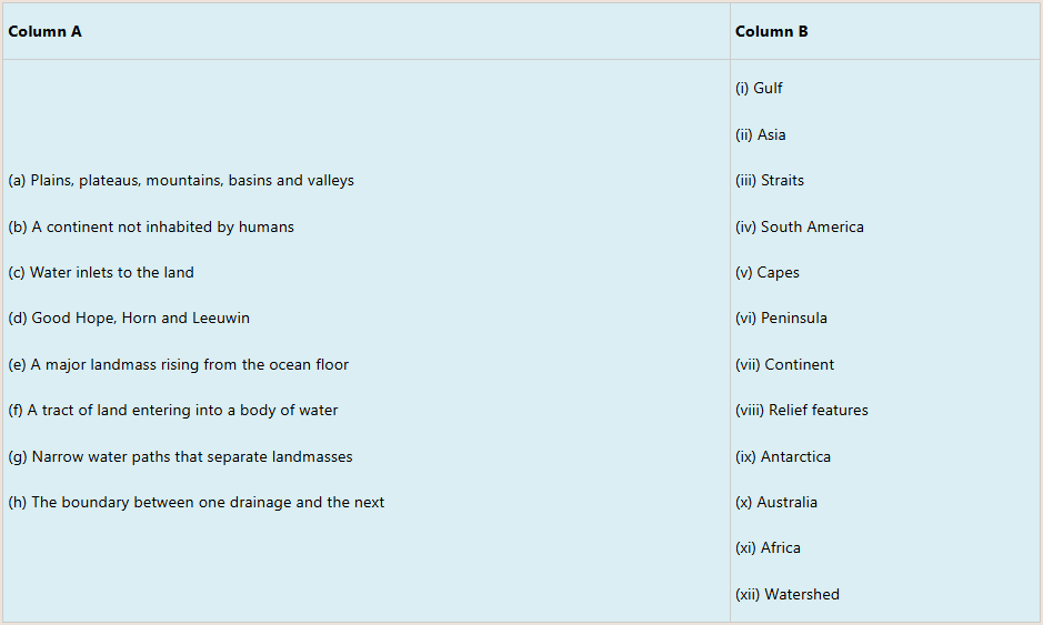
12. Match the description of land mass given in Column A with its corresponding responses in Column B.
SECTION D:
Read carefully the following statements and write T for a TRUE statement and F for a FALSE statement. Give reason for your response:
13. The Antarctica is the warmest continent on earth.
14. Ocean ridges and residual mountains are features of the ocean floor.
15. Ocean floors have relief features such as plains, ridges, slopes and basins.
16. Kilimanjaro Mountain is an example of an extinct volcano.
17. Block Mountains are also known as residual mountains.
18. The ocean water is distributed equally between the northern and southern hemispheres.
19. The formation of residual mountains is associated with the erosion process.
20. The Great African Rift Valley is the longest valley in the world.
21. Zanzibar and the Comoros are archipelagos.
22. Sea water is saline in nature.
SECTION E:
Answer the following questions
23. Which vegetation type is commonly found on the slopes of Mount Kilimanjaro in Tanzania, and what are its main characteristics?
24. Describe the dominant vegetation type prevalent in the Serengeti National Park of Tanzania, and its significance for wildlife conservation.
25. Which vegetation zone can be found in the coastal regions of Tanzania, and how does it adapt to the marine environment?
26. Name the vegetation zone found in the Ngorongoro Crater, and explains how its significance to livelihood of the Maasai community in the area.
27. What are the primary vegetation types in the Eastern Arc Mountains of Tanzania, and what makes this region biologically important?
28. Describe the vegetation types present in the Selous Game Reserve, and discuss the challenges it faces due to human activities.
29. Which vegetation types can be observed in the Mahale Mountains?
30. What vegetation type is prevalent in the southern highlands of Tanzania, and how does it support the agriculture in Tanzania?
31. What kind of vegetation is found around Lake Victoria, and how does it contribute to the lake’s ecological balance?
32. Discuss the unique characteristics of the Udzungwa Mountains vegetation type in Tanzania, and its role in species conservation.